The Cedar Falls Trail is one of Arkansas’ classic hikes. It drops down through the forest, winds along a rocky path, crosses a creek, and ends at one of the most picturesque waterfalls in the entire state.
But what most people don’t realize is that Cedar Falls isn’t just a photo stop. The pool at the base of the falls is deep enough to swim in, and you can walk around nearly the entire basin. You can even climb up behind the falls to explore the waterfall from every angle.
In this guide, I’ll share everything you need to know about hiking the Cedar Falls Trail, including how to get there, what the hike is like, and tips from my own experience to help you make the most of your trip to this iconic Arkansas waterfall.


Cedar Falls Trail Complete Guide
The Cedar Falls Trail in Petit Jean State Park is one of the most popular hikes in Arkansas. It’s a rugged, two-mile round-trip trail that goes down into Cedar Canyon and ends at the base of the 95-foot Cedar Falls.
As the trail descends into the canyon, the habitat shifts from dry upland forest to wetter, lush greenery on the canyon floor. The trail levels out and runs alongside Cedar Creek and goes upstream toward the waterfall.
Cedar Falls is the turnaround point of the hike. The waterfall drops dramatically into a large circular basin, with scattered boulders that make great spots to sit and hang out.
You can explore around the pool, go for a swim, or even carefully make your way behind the waterfall when conditions allow. The falls can be a powerful roar or a gentle flow of water, depending on recent rainfall.
The return hike is uphill, and while it’s not long, it can be strenuous, especially during summer. Take your time, bring water, and be prepared for uneven terrain.


Cedar Falls Trail Hike Details
- Hike Distance: The total distance of the hike is about 2 miles. 1 mile out + 1 mile back.
- Hike Duration: The hike takes about 1.5 hours total, including time spent sightseeing and hanging out at the waterfall.
- Hike Difficulty: The trail is moderately difficult. The hardest part is the initial descent. It’s a steep, rocky trail with switchbacks. You definitely need shoes for this one, and it will be very slippery if you hike it in the rain. Bring at least 1 liter of water, especially if it’s hot out.
- Hike Incline: The total incline for this hike is about 350 feet. It loses 250 feet of elevation within the first quarter mile of distance, so it’s quite a steep trail. But after the initial descent, the trail flattens out and follows the creek the rest of the way to the falls.
- Dogs are allowed on this trail but need to be kept on a leash. Keep in mind it is a very popular trail and there will be other hikers with dogs as well.

How to get to Cedar Falls Trail
There are two main ways to access the Cedar Falls Trail, depending on how much hiking you want to do and what kind of views you’re after.
Option 1: Start at Mather Lodge (Easiest Route)
The most direct way is to park at Mather Lodge, where the official trailhead begins just behind the lodge. This is the standard route most people take, and it leads you straight down to the falls without any extra mileage.
Below is the exact location for Mather Lodge, which is the official starting point of the Cedar Falls Trail.

Option 2: Start at Cedar Falls Overlook (Scenic Route)
Your other option is to park at the Cedar Falls Overlook. From there, you can see Cedar Falls from above, then hike a short trail over to Mather Lodge. Once you get to Mather Lodge, you’ll begin the main hike down to the falls.
The route from the Cedar Falls Overlook adds a bit of distance, but you’ll get to see the waterfall from both above and below. That’s the route we took.

Cedar Falls Trail: My Experience
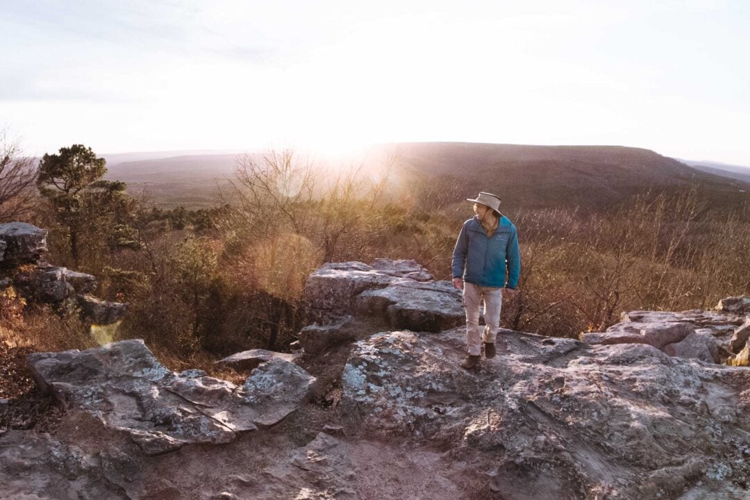
We started our hike at the Cedar Falls Overlook instead of the usual Mather Lodge trailhead. Most people skip the overlook, but we wanted to see the falls from above first. And since there’s a short connecting trail between the overlook and the lodge, it made sense.
If you haven’t been to the overlook, it’s worth a stop before starting the hike. The overlook consists of a boardwalk that zigzags through the trees and ends at a wide wooden railing with several spots to view the waterfall. It gives you a sneak peek at what’s ahead and a real sense of how far down you’ll be hiking.
From the overlook, I caught a glimpse of Cedar Falls, but the view was partially blocked by trees. It just made me more eager to get down there to see the waterfall up close.
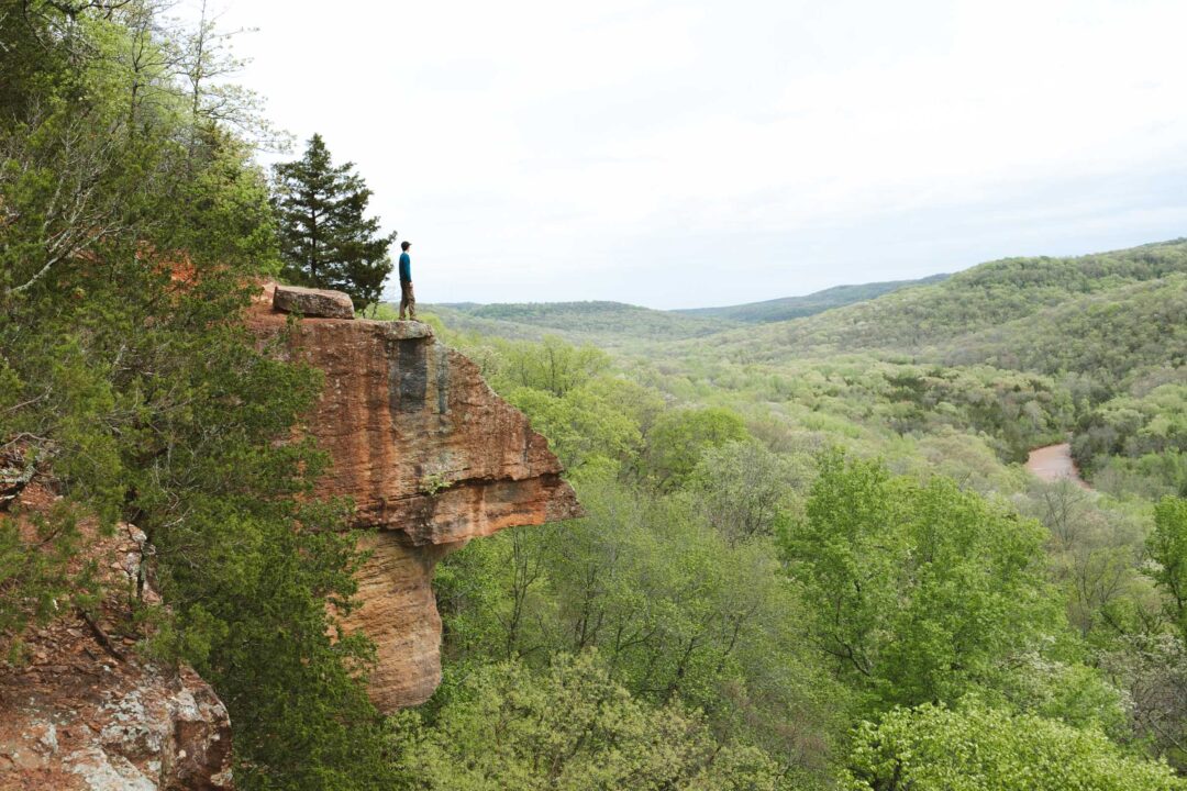
We continued on to Mather Lodge, which sits right on the edge of the canyon. The view from the lodge was incredible. The wooden beams of the Lodge’s breezeway framed the mountain vistas beyond. Honestly, it’s one of the most scenic spots in the whole park.
I spotted a rocky outcropping that jutted out into the background and took a moment to get a photo there. It’s hard to believe that there was already an epic view, and we hadn’t even started the real hike.


From there, we picked up the official Cedar Falls Trail. The descent started immediately, zigzagging down through a series of tight switchbacks.
The first part of the trail was rocky, full of exposed tree roots, and uneven. If you’ve got bad knees or shaky ankles, take it slow. It’s definitely one of those trails where footing matters.


But the switchbacks didn’t last too long, and before we knew it, we were down in the canyon. It was a nice change of pace to be on relatively flat ground.
We soon reached a sturdy bridge that crossed the creek, and after letting the dogs get a drink, we followed the creek upstream into the canyon.

The next part of the trail was the most interesting. Massive boulders lined the trail, and I couldn’t help but wonder how they got there, or how long they’d been sitting like that. The whole area felt ancient, like the canyon had been carved out slowly over time, and these huge rocks were the leftovers.


Before long, we heard the waterfall. The constant rushing sound of water got louder and louder.
We climbed over some rocks and got our first full view of Cedar Falls. The falls dropped dramatically into a wide, circular basin, with boulders scattered all around the edges.
A few families were posted up nearby, swimming, snacking, and soaking it all in. I didn’t expect it to be warm enough to swim, but seeing them in the water made me wish I’d brought a pair of swim trunks.


I spotted a narrow shelf behind the falls and decided to go for it. I crossed the creek, hopping from rock to rock, and picked my way along the bank on the right side.
As I approached the falls, the mist sprayed heavier and heavier. It was like standing in a light rain. Everything was slick, so I had to move slowly and watch my step.


I climbed up onto a ledge behind the falls. It was an entirely different experience underneath the rocky shelf.
Water roared down just in front of me, and the whole area vibrated with sound. Somewhat safe, but also raging and dangerous at the same time.


After exploring all around the waterfall, it was time to head back. The hike up the trail was easier than expected. We took the switchbacks slow and steady, and before long we were back at the lodge. Tired, a little muddy, but totally glad we did it.

Cedar Falls Trail Photos


Looking for more things to do in Arkansas?
I grew up spending my summers in Arkansas and have been all over the state. To help fellow adventurers, I’ve put together guides to the best places I found. You can check them out by clicking the links below.
- My ultimate Arkansas hiking guide: 8 Incredible Hikes in Arkansas: Complete Travel Guide
- Best canoe/kayak adventure in Arkansas: How to Float the Buffalo River
- My favorite hike in Arkansas: Seven Hollows Trail
- Best waterfall hike in Arkansas: Cedar Falls Trail
- Most dangerous hike in Arkansas: Centerpoint to Big Bluff Goat Trail

I hope you enjoyed my guide to the Cedar Falls Trail in Arkansas. Feel free to leave a comment below if you have any questions 🐸