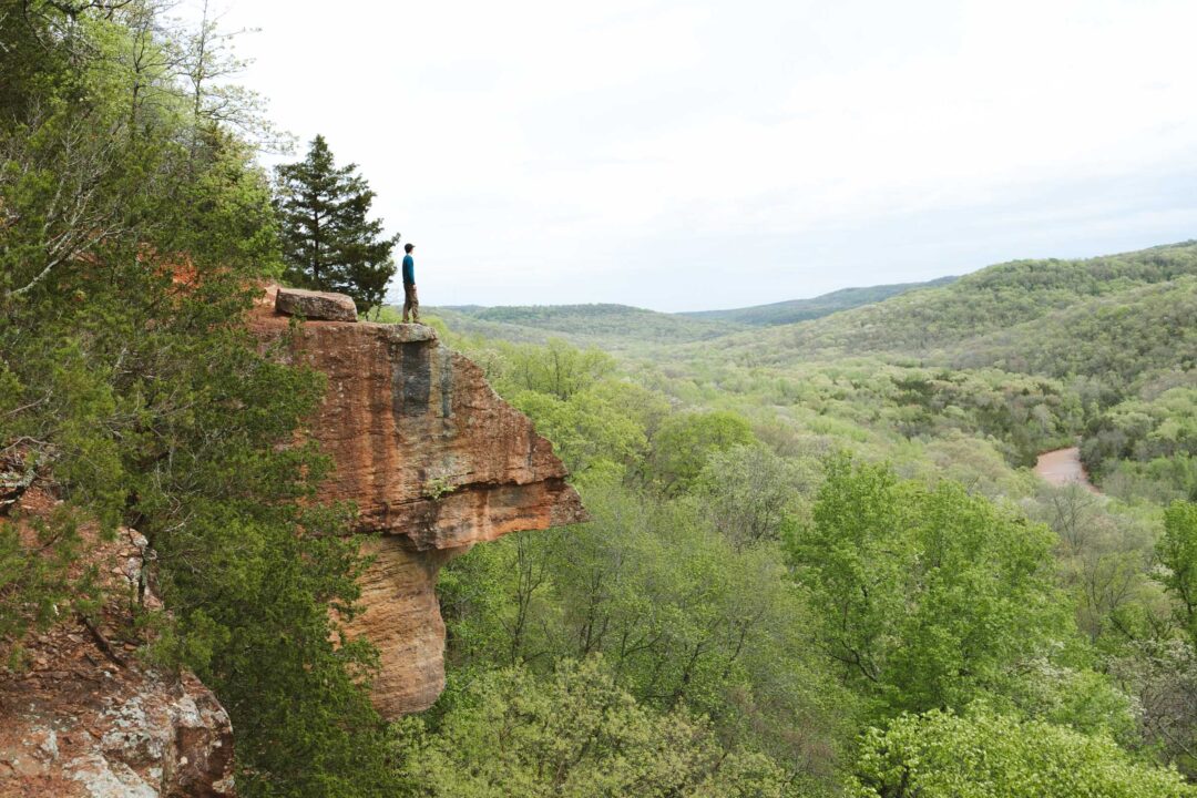
Big Bluff is one of the crown jewels of the Buffalo National River. It’s the tallest sheer bluff face along the entire Buffalo River, towering 550 feet above the water.
What’s even crazier is that there’s a trail that goes right through the bluff itself. The Goat Trail skirts the bluff, giving you an unparalleled view of the Buffalo River and a close-up look at limestone formations that make up Big Bluff.
In this guide, I’ll share what you need to know before hiking the Centerpoint to Big Bluff Goat Trail, including how to get there and what to expect on this epic hike along Arkansas’ Buffalo National River.


Centerpoint to Big Bluff Goat Trail Complete Guide
Getting to Big Bluff can be done multiple ways, but the easiest and most straightforward way is by taking the Centerpoint Trail, then walking along the Goat Trail.
The Goat Trail itself is legendary. It’s a narrow ledge carved directly into the cliffside of Big Bluff, and just wide enough to walk across. It feels unreal when you’re standing on it.
The trail is not officially dangerous if you’re careful, but let’s just say you need to watch your step. There are no barriers. It’s just you, the trail, and a straight drop off the bluff into to the forest and river below.
But from Big Bluff, the view is mind-blowing. You get a look directly over the Buffalo River snaking through the green Ozark mountains. On a clear day, you can see for miles. Layers and layers of forested mountains rolling away into the distance.


Centerpoint to Big Bluff Goat Trail Hike Details
- Hike Distance: The total distance of the hike was about 6 miles, out-and-back.
- Hike Duration: The hike will took us about 4 hours total, including time spent sightseeing and hanging out at the Big Bluff.
- Hike Difficulty: The trail isn’t in the best shape. There is a steep portion with tons of loose rock, but it’s easily doable if you take your time. There are also a few trees fallen over the trail which you need to climb over. But in my opinion, the most difficult portion of this trail is the hike back, which is all uphill. Bring plenty of water especially if it’s hot out, because the return trip feels like it never ends.
- Hike Incline: The total incline for this hike is about 1200 feet. On the way out, the hike is all downhill, and on the way back, the hike is all uphill.
- Dogs are not allowed on this trail.


How to get to Big Bluff Goat Trail
The easiest and most direct way to get to Big Bluff is via the Centerpoint Trail, which starts right off Highway 43 near Ponca. That’s the most direct route to Big Bluff and the same route we took to get there.
About 2.5 miles into the Centerpoint Trail is the turnoff for the Goat Trail. The Goat Trail skirts through the Big Bluff, where it becomes a narrow hike with a sheer 350-foot drop-off to the Buffalo River on one side.
Now, when I say it’s the “easiest way,” keep in mind that doesn’t mean it’s easy. The trail isn’t technical or confusing, it’s well-marked and simple to follow. But it is a workout.
The hike out to Big Bluff is mostly downhill, which feels great on the way in. But the hike back is a burner. It’s three solid miles of steady uphill, and in the summer heat, it’s no joke.
In fact, this trail sees more Search & Rescue calls than almost anywhere else in the Buffalo National River area. It’s beautiful, but it’s also a workout.


Centerpoint to Big Bluff Goat Trail: My Experience
We started our hike at the Centerpoint Trailhead on Highway 43. When we pulled into the parking lot, I was surprised to see only a few other cars there. I guess that’s the advantage of hiking on a weekday. You might just have the place mostly to yourself.
The trail began with a steady downhill grade, winding through new growth forest. Honestly, the first stretch wasn’t very exciting. It was just woods and more woods without much else to see. It was hard to believe such a massive bluff with some of the best views in Arkansas was waiting for us at the end of a trail that started off so underwhelming.

About halfway in, we came to a small creek crossing. With boulders laid diagonally over the crossing. My dad and I tried to figure out if they were there to block debris or ATVs. Maybe both.

The trail opened up into a flat area with a couple of campsites. It looked like a great spot to stay the night. I wouldn’t mind camping there since it is quiet, shaded, and level. This was also where the Goat Trail branched off. It would be easy to miss if it weren’t for a rocky arrow on the ground pointing the way.
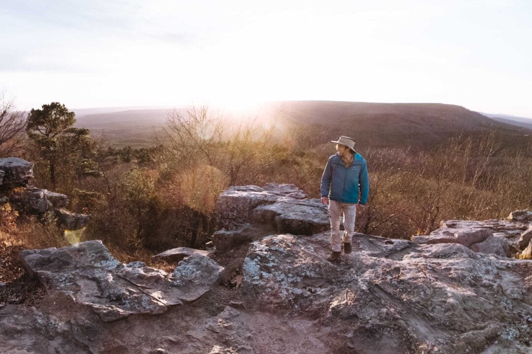
From there, things started to get interesting. The landscape shifted dramatically. On our left, a rock wall rose up beside us, and suddenly we were no longer just in the woods. We were on the edge of a bluff.

Excitement started to build and I stopped every minute just to look up at the bluff that had started to tower above me. I saw layers of limestone stacked on top of each other, each eroded differently by time and water. It’s wild to think the Buffalo River once flowed this high, slowly carving down through the Ozark Plateau to create the mountainous terrain we were hiking through.


But what was even crazier was that we were perched up on the bluff itself. The view was unreal.
Despite hiking downhill to get to this point, we now found ourselves higher than ever before, hundreds of feet above the Buffalo River. A sheer drop opened up beside us, revealing a horseshoe bend in the river below.

We followed the Goat Trail a bit further.
One section was a little sketchy. A trickle of water had created a slick patch across the trail. Fortunately, it was flat there, so we crossed it easily. After that, the Goat Trail began winding downhill again into the trees. That’s where we turned around.
We headed back to the middle of Big Bluff and took a break.
As we sat in the bluff eating our snacks, we heard voices echoing through the valley. At first, I thought it was hikers coming down the trail. But eventually we realized the sound was carrying up from the river. It was a group of kayakers. The acoustics were so sharp, they sounded like they were much closer than they actually were.
After resting, we packed up and began the trek out.
The return hike was a grind. That easy downhill we floated down earlier was now an uphill battle. We paced ourselves and stopped to catch our breath a few times. But even through the sweat, our hike to Big Bluff was absolutely worth it.

Centerpoint to Big Bluff Goat Trail Photos


Looking for more things to do in Arkansas?
I grew up spending my summers in Arkansas and have been all over the state. To help fellow adventurers, I’ve put together guides to the best places I found. You can check them out by clicking the links below.
- My ultimate Arkansas hiking guide: 8 Incredible Hikes in Arkansas: Complete Travel Guide
- Best canoe/kayak adventure in Arkansas: How to Float the Buffalo River
- My favorite hike in Arkansas: Seven Hollows Trail
- Best waterfall hike in Arkansas: Cedar Falls Trail
- Most dangerous hike in Arkansas: Centerpoint to Big Bluff Goat Trail
I hope you enjoyed my hiking guide to the Centerpoint to Big Bluff Goat Trail in Arkansas. Feel free to leave a comment below if you have any questions 🐸