When we started the hike to Heather Lake, I didn’t expect the trail itself to be so interesting. The path was rugged in some areas as we traversed over slick roots and large rocks, with massive old-growth stumps dotting the way.
But while Heather Lake is often overshadowed by the nearby Lake 22 hike, it has its own unique beauty. It may not have the same dramatic waterfalls or wooden bridges, but its rugged trail, fewer crowds, and interesting plant history make it a fantastic adventure in its own right.
In this guide, I’ll share everything you need to know before hiking to Heather Lake, including how to get there, what to expect on the trail, and tips from our own experience to help you make the most of your hike to this pristine alpine lake in Washington.


Heather Lake Complete Guide
Heather Lake is a popular day hike near Seattle. The 4.2-mile round-trip trail gains about 1,000 feet in elevation and is a solid hike without being too intense.
The trail begins climbing almost immediately, winding through a second-growth forest where giant stumps from the logging era still remain as reminders of the area’s history. Some of these stumps now host new trees growing straight out of them. It’s a cool example of nature reclaiming its space.

The trail then follows a series of switchbacks, with roots and rocks keeping things interesting. The hike levels out briefly as it follows an old logging road, then picks up elevation again as it reenters the forest.
From this point forward, the trail becomes a bit more rugged. There is a steep, rooted section and a rocky scramble in particular. Some parts of the trail are worn down and uneven, with old wooden steps left broken or washed out.


A fallen tree with a huge exposed root bed serves as a landmark, and the best way past it is by climbing through a notch that’s been carved out of its trunk.
As you approach Heather Lake, the trail flattens out and the landscape gets a bit marshy. Just before reaching the lake, you’ll hit a fork in the trail. Both paths loop around Heather Lake.
The loop around Heather Lake adds about 0.8 miles of flat, scenic walking. I recommend hiking the loop as it has so many awesome vantage points of the lake.


Heather Lake Hike Details
- Hike Distance: The total distance of the hike is about 4.2 miles, out-and-back. Add another 0.8 miles if you hike the loop trail around the lake.
- Hike Duration: The hike takes about 3-4 hours total, including time spent relaxing at the Lake.
- Hike Difficulty: The trail’s difficulty is moderate. There aren’t any steep climbs, but the trail is rocky, has big tree roots, and can be slippery in some places. The trail is mostly shaded, but you should bring at least 2 liters of water, especially if it’s hot out.
- Hike Incline: The total incline for this hike is about 1000 feet. The trail is uphill almost the entire way, and flattens out as it nears Heather Lake. There are a few switchbacks along the trail, but overall, the trail is not super steep.
- Fishing: There are said to be rainbow trout in Heather Lake. We saw two fishermen at the lake, but they told me they had no luck so far.
- Dogs are allowed on this trail, but must be on a leash. It is a popular trail so you will likely run into other hikers with dogs.
- A Northwest Forest Pass is required to park at the Heather Lake trailhead.


How to get to the Heather Lake Trail
The trail entrance for Heather Lake is located on the NF-4220 road. It’s an unpaved road located off the Mountain Loop Highway outside of Granite Falls, Washington.
The road is in good shape, and you don’t need a four-wheel drive vehicle to get there unless it’s been snowing.
The trailhead has parking on either side of the road and a larger overflow parking area behind the restrooms.
The map location below for the Heather Lake trailhead is accurate and can be used to navigate there.

Heather Lake Hike: Our Experience
As we pulled into the Heather Lake parking lot, a logging truck rumbled past in the opposite direction. Looking back, it was quite fitting because logging would be our hike’s theme of the day.
From the moment we hit the trail, there were signs of logging everywhere. The landscape was covered in second-growth forest dotted by the rotting stumps of massive old-growth trees.
Many of the huge stumps had springboard notches carved into their sides. It was a remnant of an old technique loggers used where they would mount boards, climb the trees, and cut them from higher up.
Even the trail itself is a piece of logging history as it merged into an old logging road for a short section before returning to the forest.

But despite the clear signs of logging, the forest was still beautiful. A few old-growth trees remained, and the trail itself had a rugged beauty, winding past small streams under the canopy.
The trail had been navigating around tree roots for a while, but it all came to a head on a steep slope made entirely of tangled roots. I wonder how this section of the trail came to be like this? Was all the soil washed away, leaving only the roots behind?
Not long after the steep roots in the trail, we hit a steep rock in the trail. It was a little slick, and I had to pause for a moment to figure out the best route up.


As the trail got higher, it got muddier. But soon it leveled out as we entered a marshland, where bright green skunk cabbage popped up in areas alongside the path.
But the mud didn’t bother us as much as the tree lying over the middle of the trail. Its root base was enormous and at least 15 feet in diameter. It goes to show that there is much more to a tree than meets the eye.


It wasn’t much further until I spotted Heather Lake through the trees. But before reaching the shore, we came to a fork in the trail and took the left path to hike the loop clockwise.
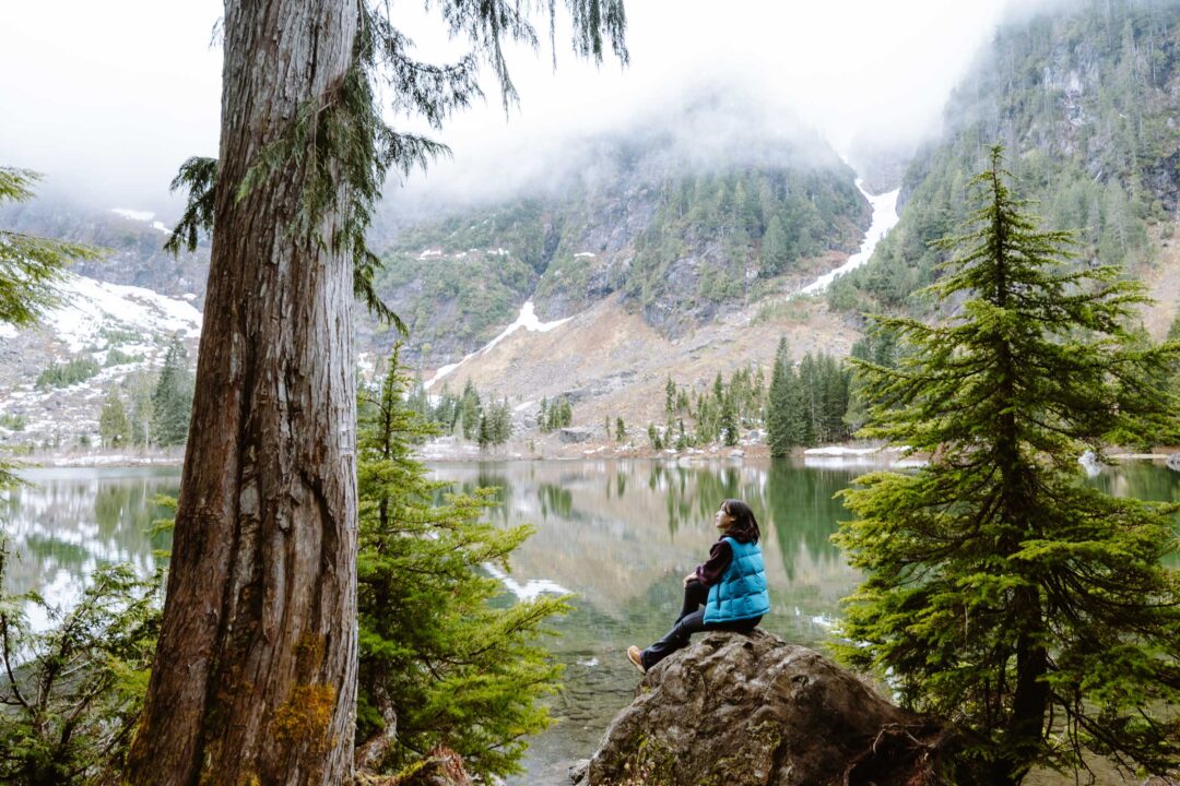
But as soon as we found a spot to reach the lake’s shoreline, we had to stop there.
Fog rolled down the surrounding cliffs toward the lake, which had a mirror-like surface from the absence of wind. The lake was silent, only interrupted by the sound of thunder roaring in the distance.
I caught a glimpse of a flash in the sky, so a storm was definitely approaching. That should have been our cue to leave, but for some reason, it did not bother us. We continued making our way around the lake.


We soon reached a wooden boardwalk cutting through a picturesque area. Trees dotted the ground with boulders sitting on the lakebed.


The boardwalk seemed to go toward the ridge behind the lake, and we spotted a snowmelt-fed waterfall roaring down the cliffside. We joked about climbing up to it, even as the wind picked up and patches of snow covered the ground.
But I had a better idea. I launched my drone to get a better look. If we couldn’t hike to the waterfall, at least the drone could. No danger, no effort.

As we walked around the back side of the lake, we ran into two fishermen casting from the shore. I asked what they were fishing for. “Supposed to be rainbow trout in here,” one of them said. “No luck yet.”

We finished the loop and made our way back down the trail. The return hike was quicker but colder now that we weren’t climbing. As we reached the trailhead, the first raindrops fell. It seems like we timed our hike perfectly.

Heather Lake Trail Photos


More Hikes Near Highway 2 in Washington
We’re based in Seattle and have done a ton of hikes all along Highway 2 in Washington. To help fellow adventurers, we’ve put together guides to the best trails we found. You can check them out by clicking the links below.
- Our Favorite Highway 2 Hike: Lake 22
- Classic Washington multi-waterfall hike: Wallace Falls Hike
- Quick hike to a wooden tower: Heybrook Lookout
- A front-row seat to a massive, misty waterfall: Bridal Veil Falls Hike
- Trail through dense mossy forest to an alpine lake: Heather Lake
- Hike to a steamy hot spring in the forest: Scenic Hot Springs

I hope you enjoyed our guide to the Heather Lake trail in Washington. Feel free to leave a comment below if you have any questions 🐸