In an area of Arkansas known for its flat-topped mountains, Petit Jean and Mount Magazine usually get all the attention.
But most people have never heard of Mount Nebo.
It’s much smaller and far less visited, but that’s part of its charm. And what Mount Nebo lacks in size, it makes up for in views.
It also has one of the more unique hikes in the state.
The Mount Nebo Rim Trail circles the entire mountain, tracing the edge of its cliffs. In just a few hours, you can walk the full perimeter, stopping at its rocky outcroppings, and soaking in the views of the Arkansas River Valley on one side, and the Ouachita Mountains on the other.
In this guide, I’ll share everything you need to know before hiking the Mount Nebo Rim Trail, including how to get there and what the trail is really like. I’ll also share my own experience hiking along the rim, including what surprised me most and why Mount Nebo ended up being one of my favorite under-the-radar hikes in Arkansas.


Mount Nebo Rim Trail Complete Guide
The Mount Nebo Rim Trail is a hike that traverses the entire perimeter of Mount Nebo. It loops around the edge of the flat-topped mountain, and because the trail stays close to the rim for most of the hike, it has constant views.
Along the trail are tons of little spots where you can stop, sit, and take in the view. This is especially true along Mount Nebo’s western rim, where rocky outcroppings jut out over the cliffs for views of the Ouachita Mountains in the distance.
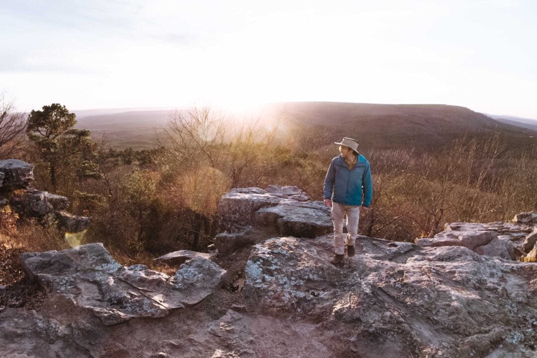
You can start the Mount Nebo Rim Trail from many points along the rim, but I recommend beginning at Sunset Point on the northwestern side of the mountain. There’s plenty of parking here, and it’s a natural starting and ending point for the loop. My walkthrough below follows the hike from this direction.

From Sunset Point, head clockwise along the rim trail, following the eastern rim of Mount Nebo. This section of the trail starts off gently as it follows the edge of the mountain behind a few houses and park buildings.
The first landmark you’ll come to is Cave Spring, located just below the rim. This spring once served as a water source for people living on Mount Nebo.

Not long after, you’ll pass the Mount Nebo Campground and cross Highway 155, the same road you drove up to reach the park.
Once you’re on the other side of the highway, the trail dips below a rocky cliff face.

This is where the hike really gets interesting.
A sheer rock wall towers above you as you walk along the trail. This vertical cliff face continues for the entire southern portion of the rim trail, and you’ll definitely want to stop and take plenty of photos. We certainly did.

As you round the corner onto the western edge of Mount Nebo, you’ll reach a trail junction. Keep right to remain on the Rim Trail. Before long, you’re hiking beneath another overhanging rock face, with the cliff curving above you as the trail hugs the mountainside.

Soon after, you’ll cross a small stream and reach the cutoff for Mount Nebo Falls. This short side trail heads downhill to the falls, and if water is flowing, it’s absolutely worth the extra time. When conditions are right, it’s one of the highlights of the hike.

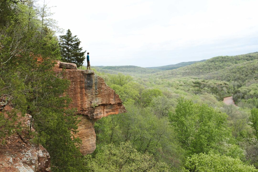
Continue along the rim trail until you reach Lover’s Leap. This area is marked by a bench overlooking a rocky outcropping, with a couple of other rocky spots nearby. It’s definitely an area to stop, relax, and take some photos as you soak in the epic views.

The trail dips back into the forest and passes the final landmark of the loop: a stone bridge built by the Civilian Conservation Corps in the 1930s. After crossing the bridge, the trail climbs back up to the rim, levels out, and soon brings you back to Sunset Point, completing the loop.


Mount Nebo Rim Trail Hike Details
- Hike Distance: The total distance of the loop hike is about 3.5 miles.
- Hike Duration: The hike took us about 3 hours total, including time spent stopping at all the viewpoints and making the short detour to Mount Nebo Falls.
- Hike Difficulty: The trail is rocky in many areas but is otherwise in good shape. Keep in mind that many parts of the trail skirt a steep cliffside, but the trail is wide enough to hike safely.
- Hike Incline: The total incline for this hike is about 850 feet. Most parts of the hike are relatively flat, but there are a few parts that go up and down a rocky trail.
- Dogs are allowed on this trail but must be on a leash.

How to get to the Mount Nebo Rim Trail
Mount Nebo is located just west of Russellville, along the northern edge of the Ouachita Mountains. It’s in a part of Arkansas known for its flat-topped mountains.
Because the Mount Nebo Rim Trail loops around the entire mountain, there are several places where you can begin the hike. That said, I recommend starting at Sunset Point on the northwestern side of Mount Nebo. This area has plenty of parking, making it one of the most convenient access points to the trail.
There’s also a small rocky overlook right next to the parking area, which serves as a natural starting point and a scenic place to return to once you’ve completed the loop.
The map location below for Sunset Point is accurate and can be used to navigate to the start of the Mount Nebo Rim Trail.

Mount Nebo Rim Trail: My Experience
Our hike along the Mount Nebo Rim Trail began at Sunset Point on the northern tip of the mountain. We followed the loop clockwise, starting with the eastern side of the rim.
The trail started off fairly flat before dropping down a rocky staircase. Not long after, we reached Cave Spring and stopped to take a closer look. It always amazes me how much water can be found underground, even at the top of a mountain.

From there, we continued along the rim trail toward the campground. We paused there for a moment to look at the campsites. It looked like a nice place to stay. I bet it gets really busy in the summer!

After we crossed the road, the trail dipped downhill and hugged a steep rocky cliff.
This was where the hike really got interesting.
The rock wall rose straight up beside us, and when I looked closely, I noticed trees growing directly out of the cliff. It’s wild how big a tree can get while growing straight out of stone. Looking downhill, we spotted small boulders littered amongst the landscape. We hurried through while hoping another one didn’t fall.

As we continued our way around the southern rim of Mount Nebo, the trail briefly opened up before narrowing again along another rocky wall. This cliff was smaller, but it curled overhead, almost like walking beneath the edge of a shallow cave. It reminded me of the Big Bluff hike in the Ozarks.

We passed between two massive boulders and soon crossed a small, gently flowing creek. This marked the cutoff for Mount Nebo Falls, so we followed the side trail downhill to check it out. The flow of the creek gave us hope, and when we reached the falls, we found a trickle spilling over the rock face. It wasn’t roaring, but it was still worth the detour.


We continued along the lower trail and rejoined the Rim Trail at Lover’s Leap. This was one of my favorite stops of the hike. A few different rocky outcroppings look west toward the Ouachita Mountains, and the bench made it a fun spot to just sit down for a while.

From there, the trail went back into the woods to an old stone bridge built by the Civilian Conservation Corps nearly a century ago. Its craftsmanship is typical for structures of that era – solid and built to last. It will easily be around for another century.
We followed the trail out of the forest and back up onto the rim. We arrived back at Sunset Point just in time to watch the sun sink below the mountains. As the light faded, the air turned chilly, and it felt like the perfect ending to the day. I was glad we saved the sunset for Sunset Point.

Mount Nebo Rim Trail Photos
Here are more photos from our hike on the Mount Nebo Rim trail to give you an idea of what the hike is like.


Looking for more things to do in Arkansas?
I grew up spending my summers in Arkansas and have been all over the state. To help fellow adventurers, I’ve put together guides to the best places I found. You can check them out by clicking the links below.
- My ultimate Arkansas hiking guide: 8 Incredible Hikes in Arkansas: Complete Travel Guide
- Best canoe/kayak adventure in Arkansas: How to Float the Buffalo River
- My favorite hike in Arkansas: Seven Hollows Trail
- Best waterfall hike in Arkansas: Cedar Falls Trail
- Most dangerous hike in Arkansas: Centerpoint to Big Bluff Goat Trail
I hope you enjoyed my guide to the Mount Nebo Rim Trail hike in Arkansas! Feel free to leave a comment below if you have any questions 🐸


Nice hike!!