The Seven Hollows Trail isn’t your typical Arkansas hike. It doesn’t build up to one big payoff like a sweeping overlook or roaring waterfall.
Instead, the trail is the payoff.
From start to finish, it winds through some of the most interesting natural features in Petit Jean State Park: rocky caves, stone bluffs, natural arches, and a tucked-away grotto with a seasonal waterfall. Every turn reveals something new.
In this guide, I’ll walk you through everything you need to know to hike the Seven Hollows Trail, including how to get there and what to expect along the way. I’ll also share tips from my own experience so you can be ready for this epic hike in Arkansas.


Seven Hollows Trail Complete Guide
The Seven Hollows Trail is a 4.2-mile loop located in Petit Jean State Park, Arkansas.
The trail gets its name from its small valleys or ‘hollows’ carved out by creeks over millions of years. These hollows give the trail its unique topography and make it one of the most interesting hikes in the state.
What makes the Seven Hollows Trail stand out is that it’s not about reaching one single viewpoint or destination. Instead, the entire trail is packed with fascinating features that make the entire journey an attraction in itself.


Highlights Along the Seven Hollows Trail
The Natural Stone Arch
One of the trail’s signature features is its natural stone arch. It’s a massive, curved rock formation that looks like a bridge.
The archway is located just off the side of the trail and is impossible to miss. You can walk beneath it and take in the scale of the stonework shaped entirely by time and erosion. It’s easily one of the most unique landscapes in Arkansas.

The Grotto
Roughly halfway through the loop, you’ll reach a short spur trail leading to the Grotto. This detour drops into a quiet hollow and ends at a wide rock overhang with a waterfall trickling into a shallow pool.
It’s a peaceful, shady spot and a great place to stop for a break or lunch. The waterfall flows best after rain, but the setting is beautiful year-round.

Caves and Rock Formations
One of the most fun parts of the Seven Hollows hike is the abundance of rock formations and caves along the way. Some are right off the trail, others require a bit of exploring.
I found myself constantly getting sidetracked, climbing up to check out one cave only to spot another rock formation just beyond it.
There is really so much exploration opportunity on this trail, and I can’t wait to return to see what else I can find.


Seven Hollows Trail Hike Details
- Hike Distance: The total distance of the hike is about 4.2 miles. It’s a loop, so you don’t need to backtrack.
- Hike Duration: The hike takes about 4 hours total, including time checking out the various caves and doing the short side trail to the grotto.
- Hike Difficulty: The trail’s difficulty is moderate. There aren’t any steep climbs, but the distance of the trail can make it difficult for some people. The trail is mostly shaded, but you should bring at least 2 liters of water, especially if it’s hot out.
- Hike Incline: The total incline for this hike is about 550 feet. On the way out, it’s all downhill, and when you loop back, it’s all uphill. However, the inclines are moderate, and some sections are relatively flat.
- Side Trail: Halfway through the hike, there is a short side trail that goes to a grotto with a small waterfall.
- Dogs are allowed on this trail but need to be kept on a leash.

How to get to the Seven Hollows Trail
The Seven Hollows Trail is located in Petit Jean State Park in Arkansas. It’s just a mile down the road from the Mather Lodge and has plenty of parking right at the trail entrance.
The map location below for Seven Hollows Trailhead is accurate and can be used to navigate there.

Seven Hollows Trail: My Experience
We started at the Seven Hollows Trailhead on a Friday morning. One of the perks of weekday hiking is having the trail to yourself. Aside from a couple of hikers finishing up as we started, we didn’t see another person the entire time.
Right away, we reached the split in the trail. You can either go left or right. It’s a loop either way. A sign pointed left toward the Natural Bridge and Grotto, so we went that direction and hiked the trail in a clockwise direction.


The hike started out mellow. It went through the trees, headed slightly downhill.
But it didn’t stay mellow for long.
Soon, rock formations and little caves began to pop up alongside the trail. We got excited and wandered over to check them out.


Looking at those caves, I couldn’t help but think about the Native Americans who once lived in the region. These shelters must have many stories to tell.
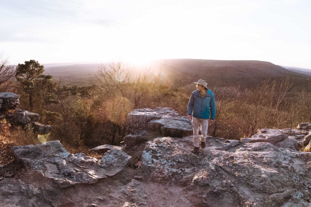
As we continued down the trail, the rock formations kept coming. A huge bluff towered over the right side of the trail. We had to control ourselves. If we explored everything we saw, we’d never finish the hike!

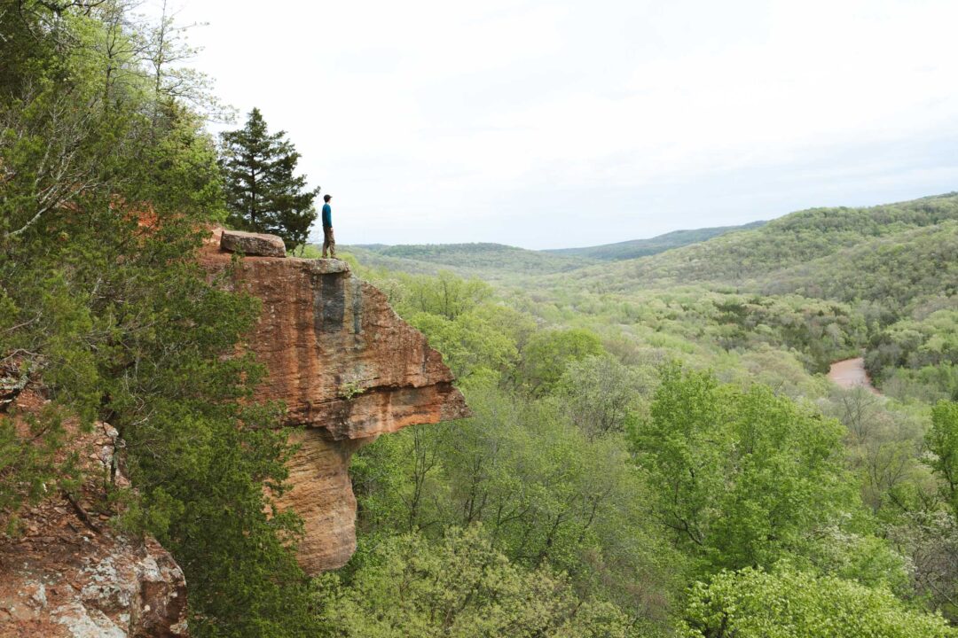
Before long, we reached the trail’s most iconic landmark: the Natural Bridge. It’s a massive stone formation that arches over a gap beside the trail.
We walked underneath the bridge, taking our time to explore the area. The archway was massive, and it made me wonder what kind of natural forces created it. Crazy geology.

After the arch, the trail climbed gradually up the bluff. It felt good to get the incline out of the way slowly instead of facing one steep climb later.
We continued down the trail and began to skirt up the side of the bluff. Then the trail climbed gradually up on top of the ridge. Soon we were on top of the bluff, looking down into the hollow we’d just come from.

I was semi-relieved. not because we had to hike uphill, but because I wanted to gradually get the incline over with, instead of a steep climb back uphill all at once.
But our uphill hike didn’t last long, and soon I spotted the side trail for the Grotto. The spur trail headed off to the right and dipped back into another hollow.
The Grotto was not far, and soon we found ourselves underneath a massive rock bluff overlooking a shallow pool with a gentle waterfall trickling down into it.


The grotto was quiet and shaded, so we found a couple of flat rocks, sat down, and had lunch. It was the perfect spot.
After lunch, we rejoined the main trail, which went around into a smaller hollow on the west end of the trail’s loop. It wasn’t as dramatic as the hollow we originally descended into, but it still had some interesting rock features.
At one point, we crossed a small stone bridge. I actually got down to confirm that it was indeed a true bridge with a gap underneath.

Eventually, the trail brought us full circle back to the parking lot. We were stoked. The trail had delivered way more than we expected.

Between the arches, caves, grotto, and quiet woods, the Seven Hollows Trail became my favorite hike in Arkansas. I can’t wait to go back and explore it again.
Seven Hollows Trail Photos


Looking for more things to do in Arkansas?
I grew up spending my summers in Arkansas and have been all over the state. To help fellow adventurers, I’ve put together guides to the best places I found. You can check them out by clicking the links below.
- My ultimate Arkansas hiking guide: 8 Incredible Hikes in Arkansas: Complete Travel Guide
- Best canoe/kayak adventure in Arkansas: How to Float the Buffalo River
- My favorite hike in Arkansas: Seven Hollows Trail
- Best waterfall hike in Arkansas: Cedar Falls Trail
- Most dangerous hike in Arkansas: Centerpoint to Big Bluff Goat Trail
I hope you enjoyed my guide to the Seven Hollows Trail in Petit Jean State Park, Arkansas. Feel free to leave a comment below if you have any questions 🐸