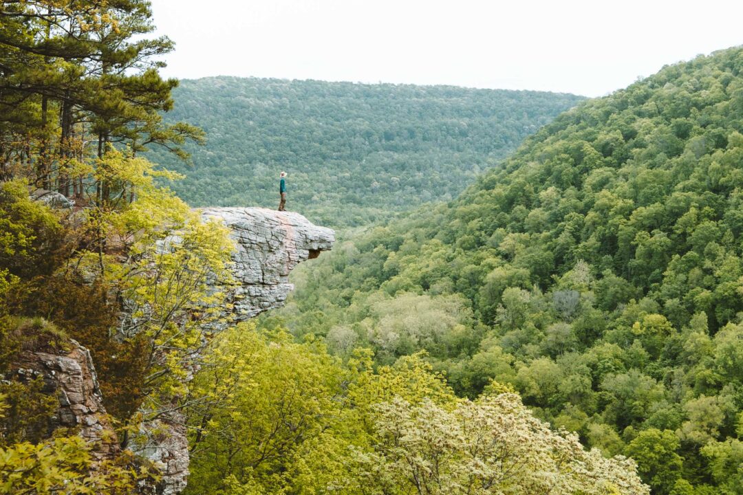
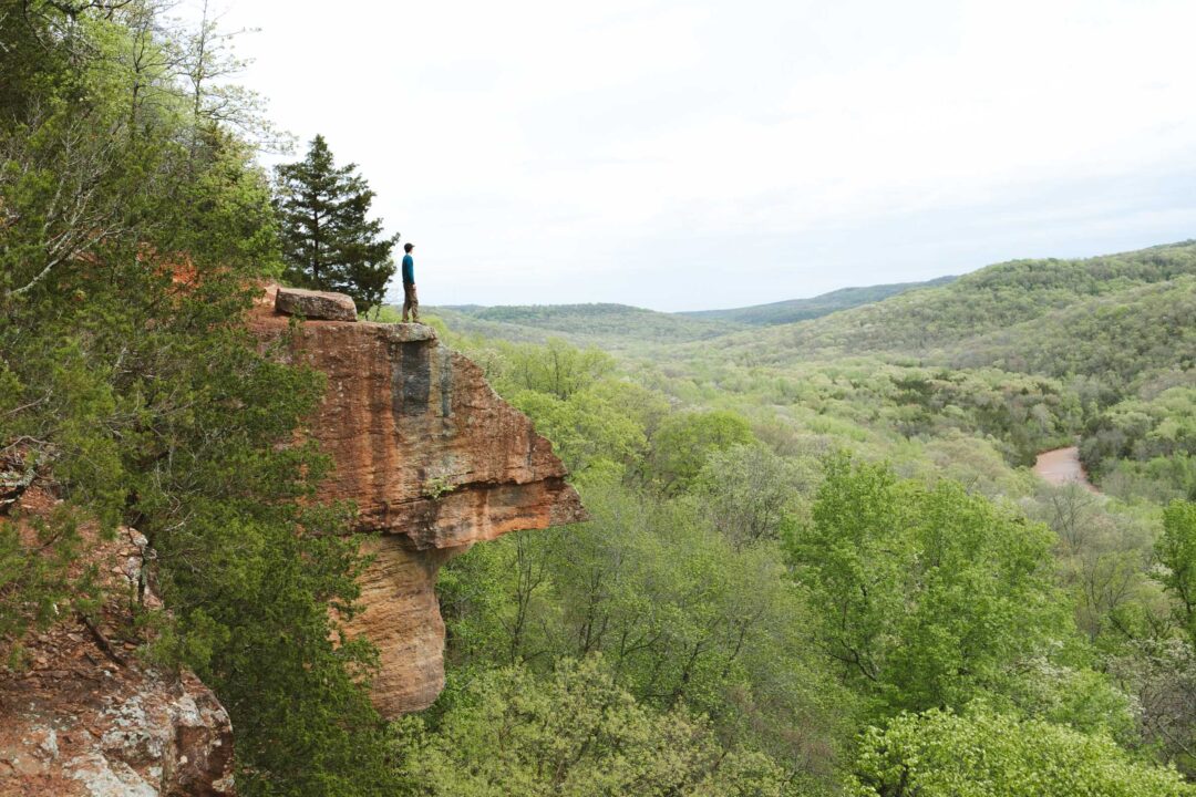
Whitaker Point is one of the most photographed spots in Arkansas. It’s that iconic rock ledge jutting out over a sweeping valley in the heart of the Ozark Mountains.
But what most people don’t realize is that the trail to this famous overlook has more to offer than just its rocky viewpoint.
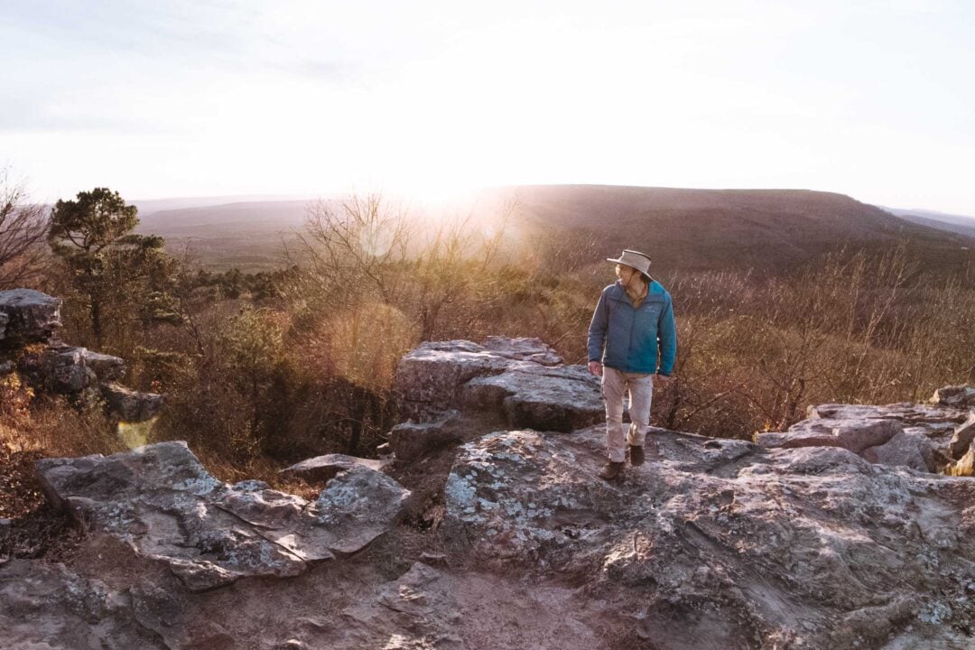
All along the cliffside, there are other rocky outcroppings where the view is just as good as the famous Whitaker Point.
And better yet, along the way, there is a short side trail to a waterfall cascading over a limestone cave. You can really see the best of Arkansas in this one hike.
In this guide, I’ll share what you need to know before hiking the Hawksbill Crag Trail to Whitaker Point, including what to bring, how to get there, and what to expect on this iconic Arkansas hike.
: Complete Hiking Guide 1")
: Complete Hiking Guide 2")
: Complete Hiking Guide 3")
Hawksbill Crag to Whitaker Point Hike Complete Guide
The Whitaker Point Trail is a short but scenic hike in the Ozark Mountains in Arkansas. The rocky point at the end of the trail is one of the postcard photos of Arkansas, and a popular spot for photographers to snap a photo looking out over the rolling green hills of the Ozarks.
The trail is well-marked and easy to follow, but the first stretch includes a steeper descent with tree roots and loose rock, so watch your footing. After that, the trail levels out and winds through forested terrain with a few stream crossings.
The main highlight, of course, is Whitaker Point. It’s a dramatic rock outcropping with panoramic views of the Ozark Mountains.
But don’t rush. Just off the main trail is a side trail that leads to Haley Falls. So you actually get both a waterfall and a panoramic viewpoint in a single hike, which is rare.
There are two other waterfalls along the side trail, Mule Trail Falls and Thousand Kisses Falls, so if you have some extra time, you can do a side trip to them too.
: Complete Hiking Guide 4")
: Complete Hiking Guide 5")
Whitaker Point (Hawksbill Crag) Hike Details
- Hike Distance: The total distance of the hike was 2.7 miles, out-and-back.
- Hike Duration: The hike will take you about 2-3 hours total, including time spent sightseeing at the overlook point.
- Hike Difficulty: The most difficult portion of this trail is the first section, which is a little steep downhill grade. If you can make it past that portion, you should have no trouble with the rest of the hike. Overall the hike is not hard.
- Hike Incline: The total incline for this hike is about 320 feet. On the way out, the hike is all downhill, and on the way back, the hike is all uphill.
- Dogs are allowed on this trail.
: Complete Hiking Guide 6")
How to get to Whitaker Point (Hawksbill Crag)
The Whitaker Point (Hawksbill Crag) Trailhead is located off County Road 5 in Madison County, Arkansas. Once you turn off the highway, you’ll be on an unpaved gravel road that leads all the way to the trailhead.
A quick note about the road: Some people say you need a 4WD vehicle to get there, but in our experience, that’s not necessary under normal conditions. Unless it’s been raining heavily or there’s snow or ice, most sedans can handle the road just fine. We saw plenty of compact cars making the drive without any problems.
As you get closer to the trailhead, you’ll find parking right next to the trail entrance and a few additional spots just before it.
The hike is popular, especially on weekends when the weather is nice. We visited on a Saturday and had no issue finding a place to park, but I would try to get there as early as you can.
The map location for Whitaker Point Hawksbill Crag Trailhead is accurate and can be used to navigate there.
: Complete Hiking Guide 7")
: Complete Hiking Guide 8")
: Complete Hiking Guide 9")
Hawksbill Crag to Whitaker Point Hike: Our Experience
We started down the trail, and the first section was the most technical. It’s a moderately steep descent with exposed tree roots, so we had to be careful of our footing.
There are a couple of spots where the trail splits, but comes back together. It’s just a matter of whether you want a shorter, steeper hike or a longer, more gradual decline. It’s your choice. We took our time here, but it wasn’t a long stretch, and soon enough the trail leveled out.
: Complete Hiking Guide 10")
: Complete Hiking Guide 11")
From there, the trail began to wind through the woods. We crossed a small creek and transitioned into a relaxing pace. This first half of the hike, while not very scenic, is more of an enjoyable walk.
: Complete Hiking Guide 12")
At one point, we passed a unique tree right in the middle of the trail. It looked like it had been burned out, with a hollow center and one side of its trunk held up by a single slab. It even had a hole through the middle of it.
My stepmom, Wen, found the tree very special and got a kick out of sticking her hand through the hole. Strangely, it was still full of foliage and very much alive. It’s one of those odd trail sights that sticks with you.
: Complete Hiking Guide 13")
We continued down the trail, and after a more prominent stream crossing, we heard the sound of a waterfall off to the side. That’s when I spotted a side trail that followed the water downhill. We decided to take a little detour and followed it to check it out.
The short side trail ended at the top of the falls. There wasn’t much of a view from above, and it was tough to see the waterfall clearly.
At first, I couldn’t figure out how to reach the base of the falls for a better view. That was, until I found a spot along the rocks where I could safely climb down, grabbing onto a tree for support.
Once I got to the bottom, I got my first good look at Haley Falls. It’s a small but beautiful waterfall flowing over a rocky ledge. Behind it was a shallow cave carved into the limestone. It reminded me of Glory Hole Falls, just without the hole.
I walked behind the falls through the cave and got a full 360-degree view of the small waterfall.
: Complete Hiking Guide 15")
I recently found out there are two more waterfalls along this trail: Mule Trail Falls and Thousand Kisses Falls. Too bad I didn’t know about them at the time, otherwise, I would have explored them too. Maybe next time.
I took a moment to appreciate the waterfall from below before looking to find my way back to the main trail. My Dad mentioned that maybe I should look for a trail instead of climbing back up. Great idea.
I followed the cliffside until I found a point where I could scramble along the rocks back into the main trail. If you want to visit this waterfall without climbing down, follow the cliff until you see a point where you can scramble down, then follow the crag down back toward the falls.
Back on the main trail, the scenery started getting a lot more interesting. We passed massive boulders lined up along the edge of the cliff. They were so perfectly placed on the cliffside that it looked like someone put them there.
Many of those boulders had flat tops, so I picked one and climbed onto the top of it for a moment to take in the view.
: Complete Hiking Guide 17")
: Complete Hiking Guide 18")
: Complete Hiking Guide 19")
Before long, we spotted the famous Whitaker Point through the trees. There is a little spot just before the point where we stood to take a photo of the rocky point from afar, to get that classic postcard Arkansas photo.
We were lucky to have the spot to ourselves for a moment, because it wasn’t too long until other hikers came down the trail and started crowding the point.
: Complete Hiking Guide 20")
: Complete Hiking Guide 21")
Right next to the main point, I spotted a small rock arch reaching out just next to the edge of the cliff. I crawled through it and looked out from the other side.
If there’s one thing I love about hikes in Arkansas, is that there are always cool rocky terrain features to explore.
: Complete Hiking Guide 22")
: Complete Hiking Guide 23")
On the way back, we retraced our steps. The return hike was smooth until we hit the final uphill stretch. It was the same steep, root-covered section we descended at the beginning. But this time we had to go up. Fortunately, this portion was short, so we paced ourselves and got back to our car at the trailhead in little time.
Looking for more things to do in Arkansas?
I grew up spending my summers in Arkansas and have been all over the state. To help fellow adventurers, I’ve put together guides to the best places I found. You can check them out by clicking the links below.
- My ultimate Arkansas hiking guide: 8 Incredible Hikes in Arkansas: Complete Travel Guide
- Best canoe/kayak adventure in Arkansas: How to Float the Buffalo River
- My favorite hike in Arkansas: Seven Hollows Trail
- Best waterfall hike in Arkansas: Cedar Falls Trail
- Most dangerous hike in Arkansas: Centerpoint to Big Bluff Goat Trail
: Complete Hiking Guide 24")
I hope you enjoyed my guide to the Whitaker Point Hawksbill Crag Trail in Arkansas. Feel free to leave a comment below if you have any questions 🐸


Nice hike bubu! When you taking me? xD