Yellow Rock Trail is one of Arkansas’ most famous hikes. It leads to a dramatic overlook perched above Lee Creek Valley in Devil’s Den State Park. Standing on the Yellow Rock provides sweeping views, and it’s often compared to the more famous Whitaker Point.
But what most people don’t realize is that there isn’t just one way to reach Yellow Rock. In fact, there are two different routes to the overlook.
I hiked both trails and created this guide to help you choose the right one, know what to expect, and make the most of your visit to Yellow Rock in Arkansas.


Yellow Rock Trail Complete Guide
The Yellow Rock Trail is the iconic hike in Devil’s Den State Park, and it has one of the best panoramic views in Arkansas.
The trail begins near Lee Creek at the Yellow Rock Trailhead. From the very start, it climbs uphill, winding through a narrow gorge and cutting directly through a massive stone bluff.
This stretch is both rugged and scenic, and goes through a unique landscape of exposed rock, mossy boulders, and occasional seasonal waterfalls after heavy rain.
Once you reach the top of the ridge, the trail flattens out and becomes more gradual. It follows the edge of the mountain, with intermittent views through the trees, before arriving at the Yellow Rock itself.


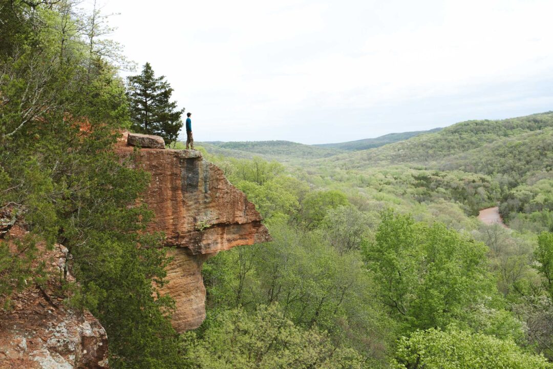
The Yellow Rock Overlook is a rocky outcropping that juts out above Lee Creek Valley. It provides an unobstructed view of the surrounding forest, rolling hills, and the creek winding in the valley below.
Alternatively, you can also hike to the Yellow Rock Overlook from the CCC Scenic Overlook. If you go this way, the trail is mostly flat and much easier. I’ll provide our experience hiking both ways in the sections below.

Yellow Rock Trail Hike Details
- Hike Distance: The total distance of the hike is about 2 miles from either direction. 1 mile out + 1 mile back. If you do the entire loop, the hike is about 2.6 miles total.
- Hike Duration: The hike takes about 1.5 hours total, including time spent sightseeing and hanging out at the Yellow Rock Overlook.
- Hike Difficulty: The trail is easy to moderate. The hardest part is the initial ascent. It’s slightly steep with switchbacks. You definitely need shoes for this one, and it will be very slippery if you hike it in the rain. Bring at least 1 liter of water, especially if it’s hot out. If you choose to do the hike from the CCC Scenic Overlook, the trail is firmly in easy territory.
- Hike Incline: The total incline for this hike is about 500 feet. Most of the incline is in the initial ascent. If you hike in from the CCC Scenic Overlook, the trail is pretty flat the entire way.
- Dogs are allowed on this trail but need to be kept on a leash. Keep in mind this is a very popular trail and there may be other hikers with dogs as well.

How to get to the Yellow Rock Overlook
There are two main ways to reach the Yellow Rock Overlook, and I hiked both. Each route provides a different experience, depending on what kind of hike you’re looking for.
Option 1: From the CCC Scenic Overlook (Easy Route)
The easiest way to get there is from the CCC Scenic Overlook on Highway 170. This trail is mostly flat with minimal elevation change, making it ideal if you’re short on time, hiking with kids, or just want the view without much effort.


Option 2: From the Yellow Rock Trailhead by Lee Creek (More Adventurous)
The more traditional route starts at the Yellow Rock Trailhead near Lee Creek. This trail is slightly shorter in distance but has a steady uphill climb to the overlook and a downhill return. It’s more challenging, but also more scenic. You’ll pass through a narrow gorge, weave between massive boulders, and walk along a bluff with great views even before you reach the top.
For extra variety, you can turn this route into a loop. The trail forms a partial circuit, allowing you to hike up one way and return on a different path that reconnects before going back down to the trailhead. It’s a great way to avoid a straight out-and-back and see more of the landscape along the way.

Yellow Rock Trail: My Experience
We had a pretty wild experience hiking the Yellow Rock Trail. Our hike was wedged perfectly between two storms. The weather forecast gave us a small window of calm, and we decided to go for it. We had to be quick before another thunderstorm was set to arrive again.
Before we even hit the trail, the area was already showing signs of heavy rain. The river was overflowing. Park benches were underwater.

When we first pulled up to the trail entrance by Lee Creek, we decided not to park there. The Lee Creek entrance sits right next to the creek, and we weren’t about to gamble with floodwaters.
Instead, we drove up to the Devil’s Den Trailhead. It was well above flood level, and from there we walked over to the Yellow Rock Trailhead to start our hike.
As soon as we hit the trail, it was obvious that this would be no ordinary hike.
Water was flowing everywhere.
The gorge near the start of the trail had turned into a small stream, with water running directly down the path. On one side, a temporary waterfall was pouring off the rock wall.


We continued up the trail before hitting my favorite part: a notch carved into a bluff. It’s a narrow cut in the rock, and on that day, water flowed across the trail under our feet.
It was so cool to be walking through this notch in the rocks, with water flowing over the rocks, dripping down around us, and turning the trail into a stream.


Eventually, the trail leveled out, and we came to a split in the trail. We followed a sign pointing toward Yellow Rock Overlook.

It wasn’t long before we came across our first obstacle. A creek rushing down the side of the mountain. I don’t know what the creek looks like on a normal day, but I doubt it’s usually that intense.
Fortunately, it was not hard to cross. A few flat rocks allowed us to hop from stone to stone without stepping in water.

The trail opened up to a wide, rocky ledge with a sweeping view of the mountains.
Just ahead, jutting out from the cliffside, was the famous Yellow Rock. Even in the overcast light and rain-soaked stone, its iconic triangular shape was unmistakable. Except this time it wasn’t so yellow. It was more orange. Probably because of the rain.
I walked out onto the Yellow Rock Overlook and took in the view. Across the valley, tree-covered slopes stretched down toward the valley floor. The creek was muddy and flowing, snaking through the park. For a few minutes, it was completely still. No wind, no rain. Just the calm between storms.

My dad caught a bit of cell service and used it to check the weather report. He confirmed what we already knew. We had less than two hours before the next round hit. So we packed up and kept moving.
Instead of heading back the same way, we continued on to the CCC Scenic Overlook.
The trail crossed a few more small streams that were flowing. I’d imagine that they are dry in better weather, but they all had well-built wooden bridges over them, so it was an easy walk.
The rain had brought everything to life, with little waterfalls and runoff channels everywhere we looked.

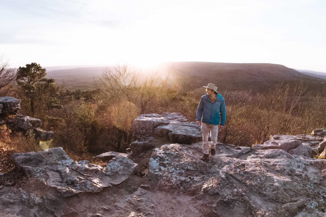
Eventually, we reached the CCC Scenic Overlook. There’s a stone pavilion there, built in the 1930s by the Civilian Conservation Corps. It’s held up well for almost 100 years.


We took a break inside the pavilion to eat lunch and admire the stonework. I noticed that the view had changed since the black-and-white photo from 1933. Back then, the landscape was much more open and void of trees. It made me wonder what this place looked like before the forest grew back in.
After lunch, we had to race the clock. We hiked quickly, retracing our steps along the loop and reconnecting with the original trail. The gorge had already started to dry out a bit, but not for long.
We made it back to the trailhead just as the first drops started to fall. Somehow, we’d threaded the needle and hiked the entire loop between two storms. We were soaked in sweat, but not rain.
Yellow Rock Trail Photos


Looking for more things to do in Arkansas?
I grew up spending my summers in Arkansas and have been all over the state. To help fellow adventurers, I’ve put together guides to the best places I found. You can check them out by clicking the links below.
- My ultimate Arkansas hiking guide: 8 Incredible Hikes in Arkansas: Complete Travel Guide
- Best canoe/kayak adventure in Arkansas: How to Float the Buffalo River
- My favorite hike in Arkansas: Seven Hollows Trail
- Best waterfall hike in Arkansas: Cedar Falls Trail
- Most dangerous hike in Arkansas: Centerpoint to Big Bluff Goat Trail
I hope you enjoyed my guide to the Yellow Rock Trail in Devil’s Den State Park, Arkansas. Feel free to leave a comment below if you have any questions 🐸


GREAT PICTURES – JUST WONDERED HAVE YOU DONE THIS TRAIL ON NEW YEARS DAY – THEY say there is a New Years day event but they used the description of Lower YELLOW Trail head by CAMPGROUND A….GUESS I WILL SEE TOMORROW – HAPPY NEW YEAR….2026