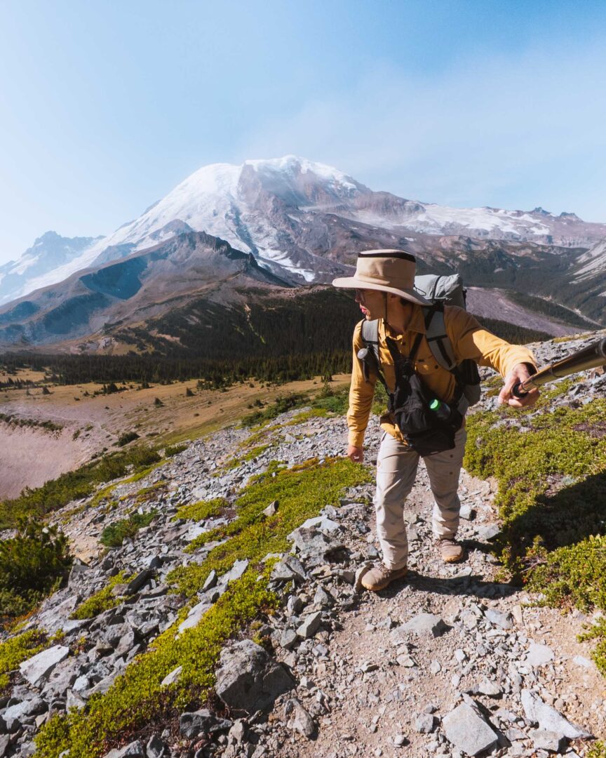
Most hikes in Mount Rainier National Park are all about the mountain itself. And don’t get me wrong, Mount Rainier is no doubt epic.
But the High Lakes Loop takes a different approach. Instead of focusing on Rainier, the trail showcases Lake Louise, framed by the backdrop of the jagged Tatoosh Range to the south.
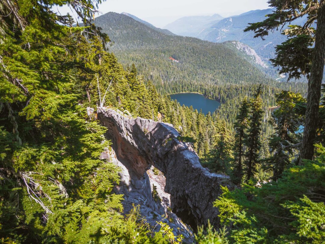
And the bluff at Faraway Rock along the trail might just be one of the park’s most underrated viewpoints. Especially since it’s not hard to get to.
In this guide, I’ll share everything you need to know about hiking the High Lakes Loop in Mount Rainier National Park. I’ll share how to get to there, what the trail is like, and tips from my own hiking experience to help you plan your adventure hiking this underrated loop trail in Mount Rainier National Park.

High Lakes Loop Complete Hiking Guide
The High Lakes Loop is a 2.8-mile easy/moderate loop trail in Mount Rainier National Park that links together sections of the Wonderland Trail, the Mazama Ridge Trail, the High Lakes Trail, and the Lower Lakes Trail.
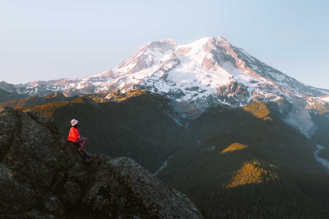
The loop circles Reflection Lakes and offers something different than most Rainier hikes. Instead of constant views of the mountain itself, the trail looks south toward the Tatoosh Mountains and over Lake Louise. At the top of the trail is the Faraway Rock viewpoint, a rocky bluff jutting out over the valley.
Since it’s a loop, you can hike it in either direction. But I recommend going counterclockwise, starting from Reflection Lakes and heading east. This way, you’ll reach Faraway Rock earlier in the hike, giving you a rest stop with a view before continuing through the meadows and finishing the loop back at your car.
I’ll describe an overview of the counterclockwise route below.
From the parking area at Reflection Lakes, start on the Wonderland Trail heading east. In the early morning, the lakes are especially beautiful with calm reflections, so it’s worth pausing there to snap the reflection of Mount Rainier in the lake before you even start hiking.

After passing the Reflection Lakes, turn left onto the Mazama Ridge Trail. The path gradually goes uphill and crosses a small stream (which may be dry later in the season).

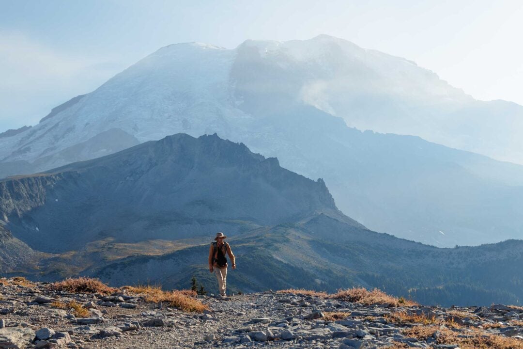
From there, the trail starts ascending up the Mazama Ridge, but not for long. The trail flattens out as it reaches the loop’s main viewpoint at Faraway Rock.
Faraway Rock is a bluff that overlooks Lake Louise with the Tatoosh Mountains rising behind it. It’s a perfect snack break spot, and it’s honestly one of the most underrated viewpoints in the park, given how easy it is to hike to.

After enjoying the views at Faraway Rock, continue west along the High Lakes Trail. This portion of the hike is very relaxed and honestly one of the best parts. It winds through a mix of forest and open meadows dotted with small wetlands.


While the views in the meadows aren’t as expansive as at the viewpoint, it’s still a picturesque place and will certainly make you stop a few times to just enjoy the surroundings. It certainly did for me.

During summer, the meadows bloom with wildflowers. You may even spot the occasional black bear, but don’t worry, they’re usually too busy munching on blueberries to care about hikers.

Eventually, the trail meets up with the Lower Lakes Loop. Turn left and follow it downhill until it reconnects with the Wonderland Trail at Reflection Lakes, and back to the parking area where you started from.

High Lakes Loop Hike Details
- Hike Distance: The total distance of the hike is 2.8 miles as a loop, from start to finish.
- Hike Duration: Hiking the High Lakes Loop trail takes approximately 2-3 hours total.
- Hike Difficulty: The trail’s difficulty is easy/moderate. The trail is in good shape and is shaded for many parts. There is some elevation gain as you hike up the ridge, but there are no technical parts, so it can be hiked by most people as long as you take your time.
- Hike Incline: The hike has an elevation gain of about 600 feet. The trail is uphill from Reflection Lakes to the High Lakes Trail and the viewpoint. The portion of the hike along the High Lakes Trail itself is a little up and down but otherwise flat as it meanders through the woods.
- Dogs are NOT allowed on this trail because it is located in Mount Rainier National Park.
- A Mount Rainier Entrance Pass is required to hike the High Lakes Loop.
Below is a map of the High Lakes Loop. I recommend using the Gaia GPS app to follow along the trail during your hike.

How to get to the trailhead for the High Lakes Loop
You’ve got two options for starting this hike:
1. Reflection Lakes Trailhead
This is the classic starting point and the one I suggest. Beginning there means you’ll tackle the uphill stretch first, then enjoy a mostly flat walk through the meadows along Mazama Ridge before finishing with a downhill return.
It makes the hike flow naturally and saves the easier sections for the second half. Plus, the Reflection Lakes parking area is much easier to get to.

2. Lower Lakes Trailhead (along Paradise Valley Road E)
The second option starts at the top of the loop at the Lower Lakes Trailhead along Paradise Valley Road. From there, you’re right next to the meadows and can reach the Faraway Rock viewpoint much quicker.
This is a great choice if you’re short on time, hiking with kids, or just want an easy out-and-back to the viewpoint instead of the full loop.
High Lakes Loop Hike in Mount Rainier: My Experience
My hike around the High Lakes Loop was a unique one.
The night before, a thick fog had rolled in. It obscured everything for miles.
By the time I drove to the trailhead before sunrise, visibility was near zero. I couldn’t even see what was too far ahead, but I figured, why not? A little weather never stops me from hitting the trail.
And it was honestly pristine.
At Reflection Lakes, the fog created an ethereal atmosphere. The still water mirrored the white veil around it, and the crisp morning air was perfect for the hike ahead.

I soon crossed the dry streambed of Sunbeam Creek, long since dried out for the season. Its log bridge now laid haphazardly in the rocks.

From there, the trail began to climb up Mazama Ridge. With the fog so thick, there wasn’t much to look at, so I quickly worked my way up.
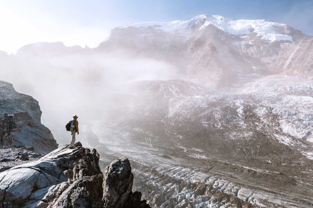
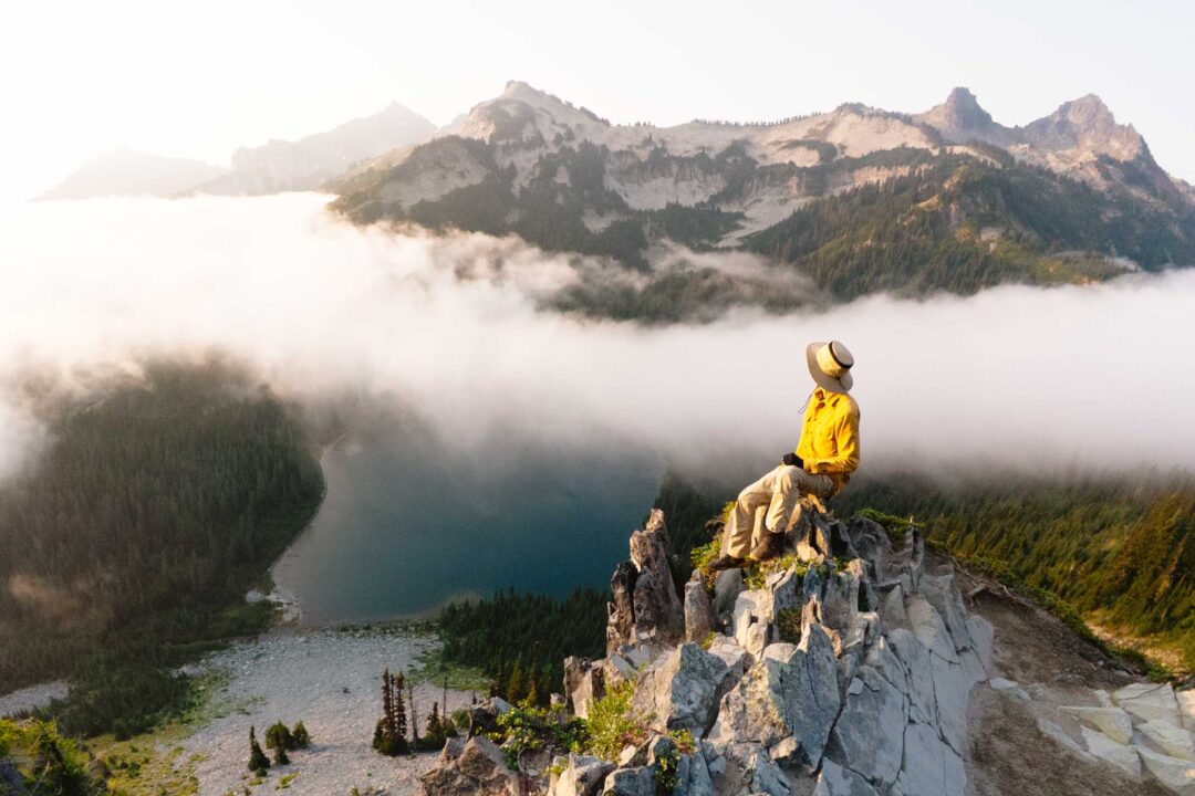
When I finally reached Faraway Rock, the main viewpoint of the hike, I was met with… more fog. The grand views I’d been looking for were completely shrouded.

But even though there was nothing to look at, I decided to sit there for a snack and just enjoy the peace. That’s when everything changed.
The fog began to thin.
Slowly, golden sunlight began to break through the clouds. The fog pulled back just enough to reveal Lake Louise glimmering below and the rugged peaks of the Tatoosh Range across the valley.
The clouds flowed over the landscape the same way a river moves through a valley, like a giant atmospheric stream.

For a few fleeting minutes, it was pure magic. I snapped photos of everything while taking it all in.
And just as quickly as it appeared, the world below me disappeared once again. The fog moved back in and swallowed everything. The landscape was shrouded in mystery once again.

That moment alone made the entire hike worth it. Sometimes nature just decides to put on an epic show. Mount Rainier is so massive that it creates its own weather patterns, and it’s one of the reasons why I’ll always keep going back there.
From there, I continued along the High Lakes Trail through the fog. I wandered along the trail between the forest, meadows, and tiny wetlands.

For such a short loop, I was surprised by how varied the terrain was. It was late summer, so blueberries were everywhere, and I stopped a few times for an early morning snack.
Eventually, the High Lakes Trail intersected with the Lower Lakes Trail, and I turned left to begin my descent back toward Reflection Lakes.

When I reached the parking area, I was stoked about that epic sunrise I just witnessed. It was a fleeting moment where the sky opened up to reveal the world below.
Our Free Mount Rainier Google Maps Locations
Want a free map of all of the locations mentioned in this post? Sign up in the box below and we’ll deliver one right to your inbox, plus our top tips to help you plan your Mount Rainier trip!
More Hikes in Mount Rainier National Park
We’re based in Seattle and have done a ton of hikes in Mount Rainier National Park. To help fellow adventurers, we’ve put together guides to the best trails we found. You can check them out by clicking the links below.
- Our ultimate Mount Rainier hiking guide: 20 Incredible Hikes in Mount Rainier: Complete Travel Guide
- Hike to a subalpine meadow with views of the Tahoma Glacier: Emerald Ridge Hike
- An old fire watch tower sitting atop a rocky peak: Gobblers Knob
- Rocky peak with an unobstructed view of Mount Rainier: Pinnacle Peak
- Explore the wildflower meadows below Rainier at Summerland, or proceed further to glacial moraines of Panhandle Gap
- Wooden fire watch tower with one of the all time best views in Mount Rainier: Fremont Lookout
- The tallest waterfall in Mount Rainier: Comet Falls
- A short hike that has big views without big crowds: Dege Peak
- 3-night backpacking adventure in Mount Rainier: Northern Loop Trail
I hope you enjoyed my guide to the High Lakes Loop hike in Mount Rainier National Park. Feel free to leave a comment below if you have any questions 🐸