Mount Catherine might just be one of the most underrated hikes in Washington. At only 1.5 miles one way (3 miles round-trip), this short trail takes you all the way to a true mountain summit. The trail gradually climbs upward through shaded forest before reaching a rocky summit with views of Mount Rainier looming in the distance.
Honestly, I couldn’t believe how high up we were for such a short hike. One minute we were in the trees, and the next we were standing on a peak with a panoramic view. Big mountain vibes without big mountain hike distance.
In this guide, I’ll share everything you need to know before hiking the Mount Catherine Trail, including how to get there, what to expect on the trail, and tips from our personal experience to help you make the most of your hike to this epic mountain summit in Washington.


Mount Catherine Complete Hiking Guide
The hike to Mount Catherine climbs 1.5 miles one way (3 miles round-trip) to a panoramic summit, making it one of the most rewarding short hikes in the Snoqualmie Pass area. It’s a moderately challenging hike, gaining about 1,300 feet in elevation over 1.5 miles. I consider it a great introduction to summit hikes in Washington thanks to its short length, nice trail, and epic views at the top.
The trailhead begins just off NF-9070 and immediately ducks into the forest. From the start, the trail climbs at a steady incline as it winds through the forest. Soon, the trail ascends a series of switchbacks that help soften the steepness of the slope. This section keeps the effort consistent but not overwhelming.
After the switchbacks, the trail flattens out briefly as it follows the ridgeline toward the summit. From there, the views start to peek out through the trees, before the trail steepens again for one final push.

Once you reach the top, you’re rewarded with a wide-open, rocky ledge and an incredible view of Mount Rainier looming to the south, with Tinkham Peak framing it to the right.

In spring or early summer, you may encounter minor obstacles like fallen trees or lingering snowbanks, especially near the top. When we hiked it in early June, the trail was clear for the most part, except for a couple of patches of snow near the summit. Microspikes aren’t always necessary, but it’s smart to bring them just in case, especially in the early hiking season.

When we hiked Mount Catherine in early June, the mosquitoes were relentless. We encountered them from the trailhead all the way to the summit. I don’t know if it’s always that bad, but if you’re hiking in late spring or early summer, it’s worth coming prepared. Long sleeves, bug spray, and even a head net will go a long way in keeping you sane on the trail (and at the summit, where they seem to gather in force).

Mount Catherine Hike Details
- Hike Distance: The total distance of the hike is 3 miles out and back.
- Hike Duration: The hike takes about 3 hours total, including time spent hanging out at the peak of Mount Catherine to enjoy the view.
- Hike Difficulty: The Mount Catherine trail difficulty is moderate. The trail is a little steep, but rather short.
- Hike Incline: The total incline for this hike is about 1300 feet. Its incline is consistent throughout the hike.
- Dogs are allowed on this trail, but must be on a leash.

How to get to the Mount Catherine Trail
The trailhead for Mount Catherine is located off NF-9070, a forest service road near Snoqualmie Pass.
After taking exit 54 off I-90, you’ll drive through the tiny town of Hyak and continue past the wastewater treatment facility. Shortly after that, you’ll connect with NF-9070. It’s a bumpy gravel road that climbs into the mountains.
The first stretch of the forest road is pretty rough and riddled with potholes, so take it slow. But it’s manageable for most vehicles, including sedans, as long as you drive carefully.
Follow NF-9070 for about 4.5 miles until you reach the trailhead. There’s no parking lot, but there are a few pull-off spots along the side of the road where you can park.
Be advised that NF-9070 closes during the winter due to snow and usually opens back up sometime in the spring.
The map location for the Mount Catherine Trailhead below is accurate and can be used to navigate there.


Mount Catherine Hike: Our Experience
We didn’t even make it out of the car before running into our first obstacle: mosquitoes. The trailhead sits near a river, so I figured that’s where they were coming from. But little did we know that mosquitoes would end up being the theme of our day.
As we started hiking up the trail, we quickly learned that we could not stop moving. If we paused for even a second, the mosquitoes would swarm us. They landed on every patch of exposed skin, one by one. Even our clothes weren’t safe. I got bit through my shirt more than once.
But Chloe took it as an opportunity to test out some bug repellent wipes she had just bought. She wiped herself down head to toe, then shoved the used wipes into her socks like some kind of bug-repelling flag. I did the same. I’m not sure whether they worked or not, because we still got bit. Maybe less than if we didn’t use the wipes.
But maybe the bugs were a good thing, because they kept us moving. I didn’t want to stop anyway, so I hiked at a slow, steady pace so I could keep going without breaks. Chloe started calling me “The Tortoise Adventures.” Hey, nothing wrong with that. Slow and steady wins the race.

The trail climbed up the mountain gradually. As the hike steepened, it turned into a series of switchbacks.
And for the most part, the trail was in great condition. Even the one big fallen tree was no big deal. We just climbed over it and kept going.


Just before the last set of switchbacks, we came across our first snowbank. We stepped over it easily, but as we hiked higher, more snow started appearing both on and off the trail.

It was early in the hiking season, so we expected some snow and packed our microspikes just in case. But we didn’t need them… until the very final stretch. A big snowbank covered the main trail at a steep angle, and it definitely wasn’t the kind you can just walk across.
Evidently, that didn’t stop other hikers because we found a little trail that skirted up the side of the mountain to the summit, allowing us to bypass the snowbank. It was short but steep, with a little bushwhacking involved.

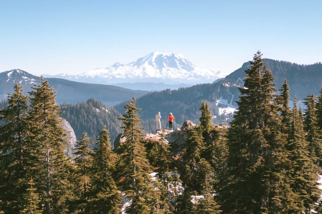
That final push was a bit of a scramble, but when I crested the top and got my first view of Mount Rainier in the distance, I completely forgot about the climb. We were standing on a proper summit, with unobstructed views to the south and a rocky ledge to hang out on. It still blows my mind how such a short hike brought us to a place that felt so high above its surroundings

We dropped our packs and took in all the views. Until I realized the mosquitoes had followed us up there. And this time, they brought reinforcements. My hopes of relaxing on the summit and eating our snacks had been shattered by those little bloodsuckers. But that didn’t stop Chloe from unwrapping her banh mi and eating the whole thing while casually swatting at mosquitoes between bites like it was just part of a picnic.

I spent the next few minutes snapping photos of the summit, especially with Mount Rainier looming in the background. It was too good of a view not to capture. Even if I had to shoot one-handed while swatting away mosquitoes with the other.
Mount Catherine Hike Photos


More Hikes Near I-90 in Washington
We’re based in Seattle and have done a ton of hikes all along I-90 in Washington. To help fellow adventurers, we’ve put together guides to the best trails we found. You can check them out by clicking the links below.
- An alpine lake framed by granite cliffs and lingering snowfields: Snow Lake
- Trek through forests to two alpine lakes nestled beneath granite slopes: Talapus and Olallie Lakes
- Hike through forest and rocky slopes with views of Mount Rainier: Mason Lake
- Short hike to a rocky summit with panoramic views: Mount Catherine
- Hike to a frozen waterfall: Franklin Falls (Winter)
- A rocky ledge with sweeping views over I-90: Dirty Harry’s Balcony

I hope you enjoyed our guide to the Mount Catherine Hike in Washington. Feel free to leave a comment below if you have any questions 🐸