Panhandle Gap is a place of extremes.
On one hand, it’s easily one of the most spectacular sections of Mount Rainier National Park: waterfalls cascade over steep cliffs while mountain goats wander through open meadows, and glacial streams weave through the landscape, giving life to alpine wildflowers.
But the beauty of Panhandle Gap also comes with challenge. Permanent snowfields persist in the area, covering steep slopes with dangerous icy crossings.
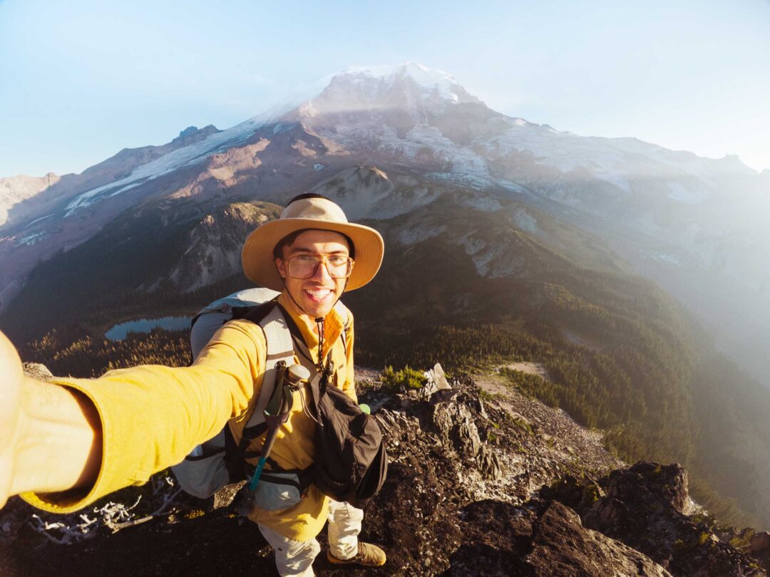
I hiked Panhandle Gap and was awestruck by its snow-covered mountains, colorful volcanic landscapes, and turquoise glacial tarns shimmering in the sun. It was like being on a different planet.
In this guide, I’ll share everything you need to know before hiking to the Panhandle Gap in Mount Rainier National Park, including how to get there, what to expect on the trail, and tips from our own experience to help you make the most of your hike to this glacial moraine in Mount Rainier.


Panhandle Gap Complete Hiking Guide
The hike to Panhandle Gap is long, but totally worth it. It brings you through some of the most dramatic areas in Mount Rainier National Park. You can really see some of the park’s best scenery all in this one hike: quiet forests, wildflower meadows, rocky moraines, and snowfields.
The trail to Panhandle Gap is in good condition, so it’s doable for most hikers with good stamina. Overall, the trail to Panhandle Gap is a well-marked, moderate/hard hike with around 3,000 feet of elevation gain over 11 miles round-trip.
The trail begins at the Summerland Trailhead near White River. For the first couple of miles, the grade is relatively flat as it passes through shaded old-growth forest.

Around the 3-mile mark, the trees begin to thin out, and soon the switchbacks appear.
By 4 miles, you’ll arrive at Summerland, where open meadows burst with wildflowers in the summer and views of Little Tahoma and Mount Rainier tower over the skyline. It’s a perfect place to rest before pushing higher.

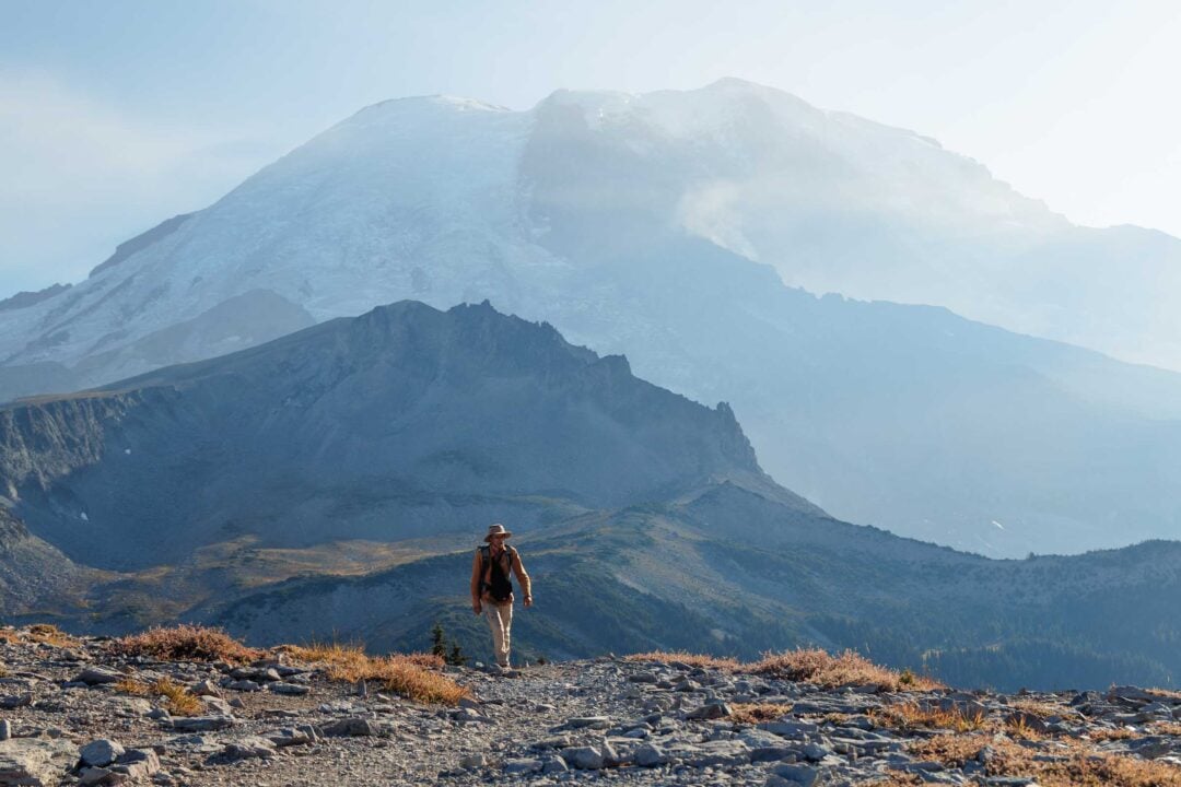
Beyond Summerland, the character of the trail changes quickly. Meadows fade as you step into a world of boulders, snow, ice, and glacial meltwater streams. Mountain goats are common in Panhandle Gap, and if you’re lucky, you might even spot a black bear passing through.

Snow is a constant factor as you make your push up to Panhandle Gap. Even in late summer, expect to cross snowfields. Some snowfields are steep and slick, so I recommend bringing hiking poles and microspikes if you have them.

At 6,800 feet, Panhandle Gap is the highest point on the entire Wonderland Trail. As you stand there, take in the views of meadow-filled valleys that sweep down into Ohanapecosh Park and Indian Bar. On clear days, Mount Adams rises above the horizon, framed by the ridges of the Cascades.

If you still have time and energy, I recommend hiking a bit further past Panhandle Gap. The landscapes only get more intense as you make your way across the moraines.

Panhandle Gap Hike Details
- Hike Distance: The total distance of the hike is about 11 miles round-trip to Panhandle Gap and back.
- Hike Duration: The hike takes approximately 7 hours in total, including time spent enjoying the views.
- Hike Difficulty: The trail’s difficulty is hard. The hike is a long distance up the mountain, and there are multiple snowfields that you must cross, even in the summer.
- Hike Incline: The total incline for this hike is about 3,000 feet.
- Dogs are NOT allowed on this trail because it is located in Mount Rainier National Park.
- A Mount Rainier Entrance Pass is required to hike to Panhandle Gap. The trail entrance for Panhandle Gap is located in the Sunrise area of Mount Rainier National Park and also requires a Sunrise Timed Entry reservation ahead of time.
The trail route to get to Panhandle Gap via the Summerland Trail is below. It is accurate and can be used to navigate the trail.

How to get to the trailhead for Panhandle Gap
The trail to Panhandle Gap starts at the Summerland Trailhead in the Sunrise area of Mount Rainier National Park. To get there, enter Mount Rainier National Park through the White River Entrance. The Summerland Trailhead is 3 miles past the White River Entrance Gate, right after the bridge that goes over Fryingpan Creek.
There is a parking area on the side of the road at the Summerland Trailhead, but you should aim to arrive there as early as you can. When we got there on a Friday at 9 AM, we were lucky to get the last parking spot in the area. Otherwise, you may need to park in a pull-out area further up the road and then walk to the trailhead.
If you want to hike to Panhandle Gap via the Summerland Trail, you will need a Sunrise Timed Entry reservation during the peak summer season. These permits are required for day-use access and can be booked in advance starting in May through the Recreation.gov website. If you miss the initial release, a limited batch of additional tickets becomes available the day before your visit at 7 PM.
Use the map below to navigate to the start of the Summerland Trail in the Sunrise parking area of Mount Rainier National Park.

Panhandle Gap Hike: My Experience
I hiked through Panhandle Gap as part of a backpacking trip with friends along the eastern portion of the Wonderland Trail.
I detailed the portion of the hike to Summerland in another blog post, but I’ll summarize it below so you can get an idea of what the entire hike is like from its start at the Summerland Trailhead all the way to Panhandle Gap.
Read my full blog post: Summerland Trail in Mount Rainier: Complete Hiking Guide
We started at the Summerland Trailhead one morning in August. The trail to Summerland started off gently as it followed an almost flat trail through old-growth forest before gradually climbing higher.

After a stretch without views, the canopy broke open to reveal rocky peaks, then closed again until we reached an old wooden bridge crossing Fryingpan Creek. We took a break there to have a snack before proceeding.

From there, the scenery opened up as we began our climb up the switchbacks in the trail to Summerland. Little Tahoma appeared first, followed by Mount Rainier.

The switchbacks themselves were in good shape and surprisingly easy to hike on. It wasn’t long until we reached the flower-filled meadows of Summerland. We stopped at a small stream crossing just beyond the camping area to refill our water bottles before continuing toward Panhandle Gap.

Things changed quickly after Summerland. It didn’t take long for the terrain to shift from grassy flower-filled meadow to dry rock-covered moraine. Streams of glacial melt trickled across the rocks, giving rise to patches of bright red wildflowers.


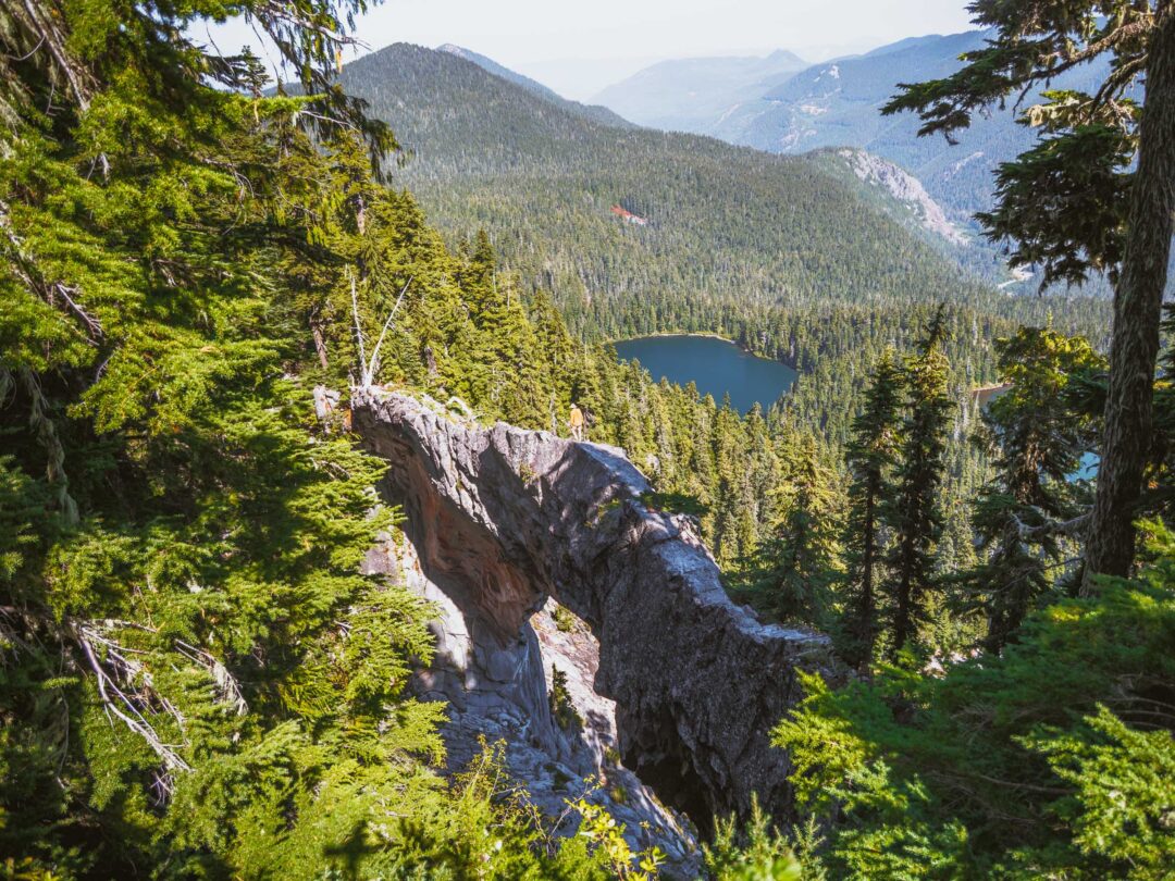
We stopped briefly at a small tarn before continuing up the trail. The color of the tarn shimmered teal blue under the sunlight. Seeing the tarn made me wonder what the area looked like when covered by snow. Did that small lake even exist during the winter? No doubt it would be just a shallow chunk of ice if it did.


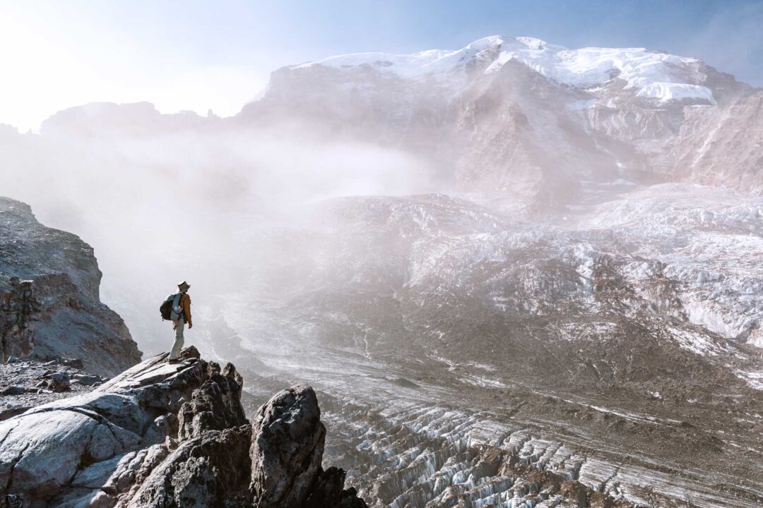
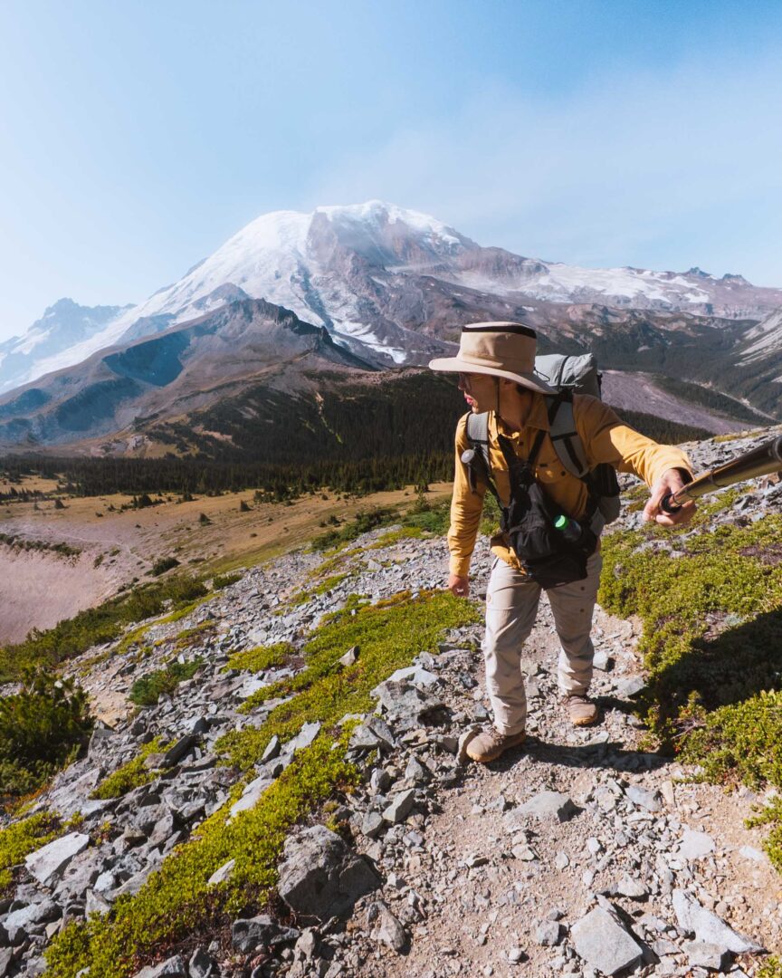
From there, our hike up the rocky trail only got better and better. Despite being in a dry, rocky volcanic landscape, the surroundings were incredible. The rocky ridges were blanketed in snow, and with each step uphill, the glacial summit of Mount Rainier became more visible.
Then came our first snowfield crossing. It was uphill, but a well-defined path of footsteps cut across it.
I planted my hiking pole firmly in the snow for balance and climbed steadily, step by step, until I was through.
Just when I stepped off the first snowfield, I spotted another one ahead. It was on a flatter stretch of land, but with just as much danger.
I noticed a bunch of rocks on the snowfield. These rocks fell recently, as they sat on top of the snow rather than under it. I looked up and noticed the crumbling rocky ridge towering above me, with slabs of stone clinging to the mountain, poised to tumble down at any second. We didn’t linger in that area.
I crossed one final snowfield before the trail leveled off, and then we were standing inside Panhandle Gap.
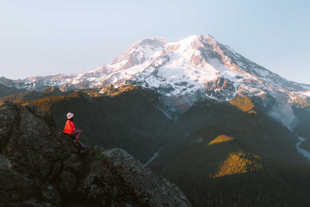
The views were incredible: Mount Adams rising in the distance, and the green meadows of Ohanapecosh Park spreading across the landscape. A herd of mountain goats grazed in a meadow far below us. They were so far away that I mistook them for a bunch of rocks until they started moving!

We found a flat spot just past the gap, dropped our packs, and had lunch with one of the finest views in the entire Wonderland Trail. After a long morning of hiking, it was a well-earned reward.

From there, we proceeded further past Panhandle Gap, following the trail toward Indian Bar. If you have the time and energy, I recommend doing the same. The landscapes beyond Panhandle Gap only get more incredible.


Panhandle Gap Hike Photos
Here are more photos from our hike to Panhandle Gap, including a few taken beyond the gap to give you a sense of just how epic the trail and landscapes are.


Our Free Mount Rainier Google Maps Locations
Want a free map of all of the locations mentioned in this post? Sign up in the box below and we’ll deliver one right to your inbox, plus our top tips to help you plan your Mount Rainier trip!
More Hikes in Mount Rainier National Park
We’re based in Seattle and have done a ton of hikes in Mount Rainier National Park. To help fellow adventurers, we’ve put together guides to the best trails we found. You can check them out by clicking the links below.
- Our ultimate Mount Rainier hiking guide: 20 Incredible Hikes in Mount Rainier: Complete Travel Guide
- Hike to a subalpine meadow with views of the Tahoma Glacier: Emerald Ridge Hike
- An old fire watch tower sitting atop a rocky peak: Gobblers Knob
- Rocky peak with an unobstructed view of Mount Rainier: Pinnacle Peak
- Explore the wildflower meadows below Rainier at Summerland, or proceed further to glacial moraines of Panhandle Gap
- Wooden fire watch tower with one of the all time best views in Mount Rainier: Fremont Lookout
- The tallest waterfall in Mount Rainier: Comet Falls
- A short hike that has big views without big crowds: Dege Peak
- 3-night backpacking adventure in Mount Rainier: Northern Loop Trail

I hope you enjoyed my guide to the Panhandle Gap hike in Mount Rainier National Park. Feel free to leave a comment below if you have any questions 🐸