The hike to Talapus and Olallie Lakes honestly surprised me. It was a gentle climb through a quiet forest of cedar and hemlock to two alpine lakes tucked beneath steep granite slopes.
But even though the trail is a popular one, it somehow still felt hidden away. And while it’s often overshadowed by the nearby Mason Lake hike, Talapus and Olallie have just as much to offer. Especially if you’re looking for a peaceful spot to camp, swim, or just sit on the lakeshore.
In this guide, I’ll share everything you need to know before hiking to Talapus and Olallie Lakes, including how to get there, what to expect on the trail, and tips from our own experience to help you make the most of your hike to these alpine lakes near Seattle.


Talapus and Olallie Lakes Complete Hiking Guide
The hike to Talapus and Olallie Lakes is a 6-mile roundtrip trek through forests of western red cedar and hemlock to two alpine lakes nestled beneath granite slopes. It’s a moderately challenging hike in terms of distance, but in my opinion is one of the easier hikes you can do near Seattle because it doesn’t have a steep incline.
Both Talapus and Olallie Lakes are popular for day hikes and camping. We saw several beautiful campsites at each lake, perfect for an overnight stay in the Alpine Lakes Wilderness.
The trail to Talapus and Olallie Lakes begins at the Talapus Lake Trailhead, at Forest Road 9030 off Exit 45 on I-90. Parking fills up fast in the summer, so arriving early isn’t a bad idea. A Northwest Forest Pass is required to park there.
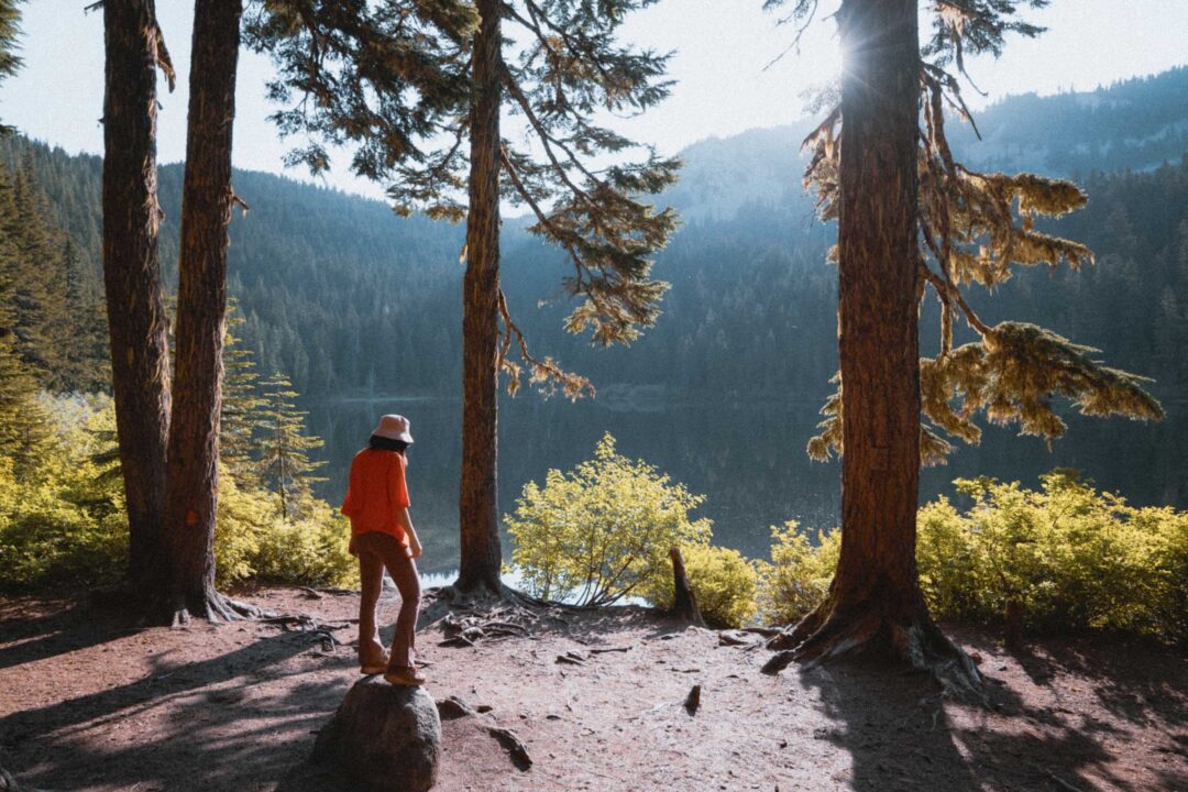
From the trailhead, the path immediately ducks into the forest and begins a steady climb up the hillside. The trail is in good shape and is shaded almost the entire way.
As it goes uphill, the trail follows a series of switchbacks before following a creek that runs down from Talapus Lake. This section of the trail is peaceful, with the sound of water guiding you along.


Talapus Lake
Roughly 1.5 miles in, you’ll reach Talapus Lake. It’s a great place to stop for a snack or just enjoy the views and vibe. A short side trail leads left along the western shore of Talapus Lake, where you’ll find several established campsites nestled among the trees.

Olallie Lake
To continue to Olallie Lake, return to the main trail and follow it as it wraps around the east side of Talapus Lake and begins climbing again. This section is a little steeper, but it’s only about 1 mile from Talapus to Olallie Lake.
Olallie Lake is slightly larger and sits in a wide basin surrounded by forested ridges. Pick a spot, take off your pack, and enjoy the scenery. If you’re camping, there are a handful of well-established sites here too.


Talapus and Olallie Lakes Hike Details
- Hike Distance: The total distance of the hike is about 6 miles, out-and-back.
- Hike Duration: The hike takes about 4-5 hours total, including time spent relaxing at the Lake.
- Hike Difficulty: The trail’s difficulty is moderate. The trail isn’t overly technical, and it’s not very long. The trail is mostly shaded, but you should bring at least 2 liters of water, especially if it’s hot out.
- Hike Incline: The total incline for this hike is about 1200 feet. The trail is uphill almost the entire way to Talapus and Olallie Lakes, but it’s not super steep. There are a few switchbacks along the trail, but they are not overly strenuous.
- Dogs are allowed on this trail but must be on a leash. It is a popular trail, so expect lots of other dogs.
- A Northwest Forest Pass is required to park at the trailhead for Talapus and Olallie Lakes.


How to get to the Talapus Lake Trailhead
The trailhead for Talapus and Olallie Lakes starts at the Talapus Lake Trailhead. It’s located off I-90 at exit 45. Follow NF-9030, then turn right at the signed junction. It’s an unpaved forest road most of the way, but can easily be done in a sedan. Just keep an eye out for a massive pothole right where the pavement turns to dirt. The rest of the road was in great shape.
The hike to Talapus and Olallie Lakes is one of the more popular hikes near Seattle, so the parking lot at the trailhead fills up fast. To avoid the parking headache, your best bet is to either arrive early in the morning (before 8 AM) or later in the afternoon (around 2 PM). By going in the afternoon, you’ll catch the turnover as morning hikers leave. If the lot is full, overflow parking is allowed along the road.
The map location below for the Talapus Lake trailhead is accurate and can be used to navigate to the start of the trail for Talapus and Olallie Lakes.


Talapus and Olallie Lakes Hike: Our Experience
We started our hike to Talapus and Olallie Lakes early. As in, 5:30 AM on a Monday. We slept in the car at the trailhead the night before just to make sure we’d be the first ones out on the trail. And it worked. The forest was completely still, and for a rare moment on a summer hike near Seattle, we had the entire place to ourselves.
As we continued up the trail, it climbed uphill gently and was honestly so relaxing compared to the uphill grind we did to Mason Lake the day before. Soon, the sunlight began to poke out of the canopy as we passed through the forests of hemlock and cedar.

After meandering through the forest, we crossed a small wooden bridge over a stream, followed by a boardwalk, and soon caught our first glimpse of Talapus Lake.
The lake was quiet and completely still in these early morning hours, and across the other side, the sun’s rays were starting to light up the mountainside. We took a few moments to explore the shores of Talapus Lake, checking out its driftwood-littered shores before setting out toward Olallie Lake.


The hike from Talapus to Olallie Lake didn’t take us very long. When we got there, we found plenty of cool little spots to hang out near the water. Olallie Lake had a peaceful vibe to it, with several campsites scattered along its shores.

Once we got to the far side of Olallie Lake, we spotted a little trail branching uphill and around the lake. It was marked as “Boot Trail” on my map. At the time, we didn’t think much of it and followed it uphill. It was steep and a bit overgrown, but it looked like a way to make a loop around Olallie Lake.
We followed the Boot Trail straight up the hillside with no switchbacks until it eventually linked up with the official Pratt Trail. This turned out to be our favorite part of the hike. The trail curved along the east side of Olallie Lake, past massive old-growth cedars and across small creeks. It was a flat, easy walk through a beautiful forest, and it gave us time to slow down and really enjoy the mountains without burning through our energy.


We reconnected with the main Talapus and Olallie Lake trail. But instead of heading straight back down, we took a little detour to explore the campsites on the west side of Talapus Lake. It was still peaceful and calm. Talapus had many cute campsites, and I hope to return there to camp sometime.

While we hung out at one of the empty campsites, a Canada jay landed in the tree above us. Not long after, a second one showed up. Curious birds. Both of them were clearly checking out whether we had any food on us. I guess they don’t call them camp robbers for nothing.
On the way back down the main trail, we ran into a forest ranger hiking up. We chatted for a bit and told her about our route. And that’s when we found out the Boot Trail wasn’t actually an official trail. She explained that they’d been trying to get it removed from maps because it has been causing erosion in the area. It totally made sense because the Boot Trail was slightly overgrown when we hiked it, and I found it unusual that it just went straight up the side of a hill with no switchbacks. She told us that it was no problem, because we didn’t know any better, but we promised her that we wouldn’t hike it again.
By the time we got back to the trailhead, the parking lot was packed. A few cars were even parked out along the road. Kind of surprising for a Monday morning, but I guess that’s just how it is in the summer for hikes near Seattle.
Photos of Talapus and Olallie Lakes Hike


More Hikes Near I-90 in Washington
We’re based in Seattle and have done a ton of hikes all along I-90 in Washington. To help fellow adventurers, we’ve put together guides to the best trails we found. You can check them out by clicking the links below.
- An alpine lake framed by granite cliffs and lingering snowfields: Snow Lake
- Trek through forests to two alpine lakes nestled beneath granite slopes: Talapus and Olallie Lakes
- Hike through forest and rocky slopes with views of Mount Rainier: Mason Lake
- Short hike to a rocky summit with panoramic views: Mount Catherine
- Hike to a frozen waterfall: Franklin Falls (Winter)
- A rocky ledge with sweeping views over I-90: Dirty Harry’s Balcony
I hope our hiking guide to Talapus and Olallie Lakes helped you in planning your adventure there. Feel free to leave a comment below if you have any questions 🐸